
New ocean technology primed to reveal Gulf of Maine's dimensions
Data could provide insights into climate change and other environmental concerns
By Lori Valigra
Printer Friendly Page
WHAT MARINE biologist wouldn't want to jump aboard Jules Verne's fictitious Nautilus submarine and
study the ocean in a living lab “Twenty Thousand Leagues Under the Sea?” While that type of fantastic
technology may never become a reality, today's scientists are improving instruments that will tell
them more about the Gulf of Maine and western Atlantic Ocean from the sea floor to its surface.
The instruments are designed to send back data as they are collecting it, rather than researchers
having to wait up to a year for an instrument to be brought in for downloading data.
Also on the surface and reaching down to about 10 meters from the ocean floor along the Gulf of
Maine coast are ten high-tech buoys managed by the Gulf of Maine Ocean Observing System (GoMOOS).
The buoys measure currents, temperature, salinity, density, oxygen and phytoplankton with the aim
of revealing more about the fine details of the water column structure.
At the ocean floor, the Gulf of Maine Mapping Initiative (GOMMI) is using so-called multibeam
acoustic and other technologies to discover more about the sea bottom's features and inhabitants.
Newer technologies may yield even more information about the Gulf of Maine. For example, the
University of Maine plans to buy gliders this fall that could move up and down the water column
and be deployed for up to six months to provide detailed information on the water and its inhabitants
at specific levels.
The new technologies have the potential to tell scientists and marine managers what types of
sediment and animals make up the sea floor, the chemical and biological composition of the water
column, plankton distribution and other information. A fuller understanding of the typical habitats
and conditions of the gulf could help identify abnormal situations that might change the health and
balance of the area. Eventually, instruments might even serve as predictors that could warn weeks
ahead of time that conditions are ripe for a possible red tide or other phenomenon.
“The Gulf of Maine is an incredibly diverse piece of coastal ocean, more so than any other piece
of coastal ocean in the United States,” said Andrew Thomas, professor of oceanography at the
University of Maine, Orono, who is leading the satellite dish program. “The diversity is what
makes it such a great laboratory for doing research.”
Satellites - the ultimate bird's eye view
Thomas hopes the data will provide new insight into the general health and functioning of the
gulf and help link these to broad scale events like shifts in the North Atlantic Oscillation (NAO).
The NAO has a major impact on western North Atlantic water masses and also on winter weather along
the Eastern Seaboard. “If our understanding is good enough to know that an NAO event is occurring,
and if we understand the dynamics well enough, in the future we will be able to make some sort of
assessment on what effect this will have on the Gulf of Maine a couple years down the road,” Thomas
said. “Will the event bring colder or warmer water into the Gulf of Maine, and is that water nutrient
rich or poor?”
The new dish still is being tested before it goes online fully in a scientific setting. It is
collecting temperature data from two NASA satellites and the ISROs Ocean Colour Monitor (OCM)
satellite, both of which deliver their data streams in a high-density X-Band transmission. The
NASA satellites, which have been in orbit for two or so years, have a sensitive instrument on
them called the moderate resolution imaging spectroradiometer (MODIS). But Thomas still plans
to keep using data from the University of Maine's older L-band satellite reception system that
gets ocean surface temperature from National Oceanographic and Atmospheric Administration (NOAA)
weather satellites.
The benefit of the new X-band satellite dish system is that both temperature and color data
can be picked up simultaneously as the satellites pass overhead. “This is an advantage when you're
trying to understand the relationship between physical processes in the ocean and the biological
response,” Thomas said. The tracking dish can follow the satellite when it is in range, and an
image of the data is ready within five minutes.
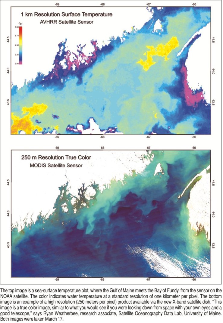
The newer satellites offer crisper images nearer to the shore. The earlier satellites show a
resolution of about one kilometer, meaning that every pixel on the computer is one kilometer big.
That makes it difficult to see details, especially near the coast line. “The OCM data has 300-meter
resolution, and MODIS has channels with 250-meter and 500-meter resolution” Thomas said. “These
higher resolutions will allow us to address marine issues much closer to the coast and in finer
detail than we were able to before.”
Buoys get more sensitive
Satellites and their receivers aren't the only instruments getting more sensitive. Neal
Pettigrew, chief scientist of GoMOOS and associate professor of physical oceanography at the
University of Maine, Orono, said his group's network of buoys soon will be fitted with more
powerful microprocessors and software that can collect and transmit more detailed information.
The buoys have been designed to accommodate more sensors and repair faulty ones with relative ease,
all within the hostile weather systems of the gulf and western Atlantic.
GoMOOS, funded primarily by NOAA, essentially expanded upon the Penobscot Bay project
throughout the Gulf of Maine. Ten buoys were first deployed in 2001 to measure a wide range of
environmental conditions including wind, waves, temperature, dissolved oxygen and color. Optical
sensors on the buoys can measure properties like chlorophyll fluorescence, which gives some measure
of how much phytoplankton is in the water. GoMOOS has a total of 20 buoys: ten are on the water from
Gloucester, Massachusetts, to Nova Scotia and the other ten are on land being repaired or upgraded at
any given time. The buoys are placed up to 15 miles off shore, or where the water is about 100
meters deep. Fishermen, scientists, surfers, the Coast Guard, the National Weather Service and
educators all access the GoMOOS Web site to get information on water conditions.
“GoMOOS was the only way to make significant progress on some of the problems we've been
studying around the Gulf of Maine for 50 years,” Pettigrew said. The buoys yielded some initial
surprises, including reversals of the coastal water system flow that scientists hadn't even
suspected. “Most water doesn't make it from eastern Maine to western Maine. It just turns offshore
around the Penobscot Bay area and recirculates or goes off into deeper water,” he said.
Since the buoys have been deployed, Pettigrew and his colleagues have worked at making them
more hardy and able to gather more information. One example was a new inductive modem system,
which is a method for sending the data from submerged sensors up to a buoy. Rather than having a
tangle of electrical wires from each of the underwater sensors to the buoy, the inductive modem
technique uses the voltage fluctuation that the sensor generates to send the data. The data are
then moved or induced into the strong steel cable that holds the buoy in place and move up the cable
to the buoy.
“GoMOOS is collecting a lot of background information now so we can start to see patterns and
start to interpret and understand what the important factors are that made the 1990s a terrific
decade for lobsters, for example, compared to the 1960s,” he said. “We don't know those answers
yet. But we feel optimistic that we're going to learn those answers as we gather more data and
see more examples of the biological variation being correlated with physical changes.”
No silver bullet
Pettigrew, Thomas and other scientists know their technologies won't be able to provide all the
information they'd like to see about the Gulf of Maine, so they are sharing data. For example,
the GoMOOS Web site includes satellite and other data such as information from the Coastal Ocean
Dynamics Application Radar (CODAR) land-based stations that use radio waves to produce maps of
ocean currents throughout the gulf. There also are regional partnerships such as the Gulf of Maine
Ocean Data Partnership that is coordinated by GoMOOS and is collecting physical, biological,
chemical and geologic data from various governmental, research, nonprofit and academic entities
including the Maine Department of Marine Resources and the National Marine Fisheries Service.
The scientists also are watching new technologies that might fill in some information gaps.
One technology they are excited about is autonomous underwater vehicles (AUVs) or gliders, which
NOAA and a handful of universities already are testing in waters. The University of Maine plans
to buy gliders and put them into the water either later this year or next year.
AUVs can provide detailed, multi-dimensional views of ocean biology, chemistry and physics
for extended periods of time, some as long as six months. The gliders can operate alone or accept
new commands from shore during a mission to change their observing strategies. They can travel for
several thousand kilometers because the sensors on board are small and require low power. Earlier
underwater vehicles called remotely operated vehicles (ROVs) were limited by the tether to a
mother ship that controlled them, although they also collected valuable samples.
“The AUVs are the most exciting new technology,” added Thomas Noji, chief of the Ecosystems
Processes Division of NOAA Fisheries' Northeast Fisheries Science Center (NEFSC) in Sandy Hook,
New Jersey. Noji said the AUVs aren't measuring the ocean in a new way; their advantage is they
can get into study areas that would be difficult or too expensive for humans to attempt.
Maps of the deep
Noji is part of the Gulf of Maine Mapping Initiative (GOMMI), a U.S.-Canadian research
collaboration to map the sea floor of the Gulf of Maine. About 15 percent of the sea floor
was mapped before the survey, and Noji said that will increase significantly when information
from a current survey is added.
Susan Snow-Cotter, director of Massachusetts Office of Coastal Zone Management, said GOMMI's
strategic goal is to completely map the Gulf of Maine using consistent technology. “We believe sea
floor mapping is useful for a range of applications for fisheries management and for environmental
management,” she said. NOAA provided the initial $1-million worth of survey time. States like
Massachusetts also are working on mapping. She added that the state recently said it would commit
$1 million toward additional mapping that will be focused on Cape Cod Bay, because the state already
has maps in the works with the U.S. Geological Survey in Woods Hole, Massachusetts, from New
Hampshire to Boston Harbor. She said the Canadian participants in GOMMI were asked recently to
create a study plan for the Bay of Fundy. “So there's good momentum north of the border as well,”
she said.
The GOMMI multibeam technology uses a wide range of frequencies to send signals to the sea
floor to see if it is hard or soft, how deep it is and get an idea of its features, such as
underwater mountains. The instrumentation includes an on-ship transducer that sends signals
to the bottom. The instruments feed information into receivers and computers. Noji said the
signals are at frequencies that “to our knowledge” do not interfere with the communications
of marine mammals.
Depending on the way a certain frequency reflects back to the ship, the receiver onboard the ship
gets information that the computers can turn into very high-resolution bathymetric maps of the sea
floor depth several hundred meters down, with accuracy within a few meters. This results in
accurate views of the positioning of the sea floor and the altitude or extent to which any
feature on the sea floor is raised above the average sea floor height.
“Offshore multibeam technology has revolutionized sea floor mapping. It's akin to what aerial
photography did for terrestrial mapping,” he said.
As excited as Noji gets about multibeam and AUV technology, he said no technology could
replace a scientist's getting his or her hands on an actual piece of sediment or habitat. Still,
he's intrigued by the advance of technology like gliders to get to new ocean frontiers. “The greatest
impediment to mapping is not so much the availability of the technology, because there's a lot of
good technology out there, but it's being able to get it into the habitats, to get it into those
areas to do some measurements,” he said.
National Marine Fisheries Service, Northeast Fisheries Science Center
University of Maine, Orono's Satellite Oceanography Data Laboratory
Gulf of Maine Mapping Initiative
Gulf of Maine Ocean Observing System
© 2005 The Gulf of Maine Times
 The diversity of the Gulf of Maine has attracted a multitude of scientists from universities,
government and private industry, along with their gizmos. The University of Maine, for example, is
in the process of testing a new, 8-foot-diameter satellite dish that will be able to collect
detailed ocean temperature and color data from newer, higher resolution satellites to study trends
on the ocean's surface.
The diversity of the Gulf of Maine has attracted a multitude of scientists from universities,
government and private industry, along with their gizmos. The University of Maine, for example, is
in the process of testing a new, 8-foot-diameter satellite dish that will be able to collect
detailed ocean temperature and color data from newer, higher resolution satellites to study trends
on the ocean's surface.
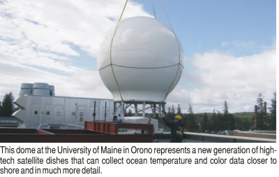 Installing the satellite dish seemed an odd event by anyone's reckoning. In mid-May, a crane
lifted a large dome atop a building in the heart of the forested campus of the University of Maine,
Orono. Though far from the sea, the dome contained the large satellite dish that would collect
highly detailed views of the ocean. It is one of a handful of such high-tech dishes in the United
States that can collect ocean temperature and color data closer to shore and in much more detail
from the newer National Aeronautics and Space Administration (NASA) and Indian Space Research
Organisation (IRSO) satellites.
Installing the satellite dish seemed an odd event by anyone's reckoning. In mid-May, a crane
lifted a large dome atop a building in the heart of the forested campus of the University of Maine,
Orono. Though far from the sea, the dome contained the large satellite dish that would collect
highly detailed views of the ocean. It is one of a handful of such high-tech dishes in the United
States that can collect ocean temperature and color data closer to shore and in much more detail
from the newer National Aeronautics and Space Administration (NASA) and Indian Space Research
Organisation (IRSO) satellites.
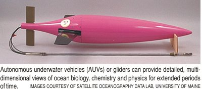 “The nice thing about the gliders is it's like a submarine slicing through the water, and it
can make excursions up and down in the water column as it's sailing along,” enthused Thomas. “So it
gives you this vertical picture of the phytoplankton and the temperature structure.” The satellite
provides a look at only the ocean surface, to give it a two-dimensional view. The glider provides
data in other directions, so it fills in the picture of what the ocean is doing.
“The nice thing about the gliders is it's like a submarine slicing through the water, and it
can make excursions up and down in the water column as it's sailing along,” enthused Thomas. “So it
gives you this vertical picture of the phytoplankton and the temperature structure.” The satellite
provides a look at only the ocean surface, to give it a two-dimensional view. The glider provides
data in other directions, so it fills in the picture of what the ocean is doing.
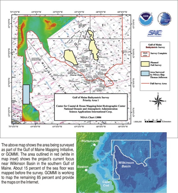 GOMMI uses a variety of technologies, an important one being the multibeam acoustic instrument
being used in a large survey of the Gulf of Maine, part of which took place earlier this year and
the remainder of which was scheduled to be completed this fall. The survey included up to 90 ship
days across a wide swath of the Gulf of Maine. The Center for Coastal Ocean Mapping at the
University of New Hampshire will do most of the basic mapping, and the NEFSC will use those maps
to help it decide where to do more groundtruth sampling and get other types of information. “We're
mostly looking for habitat characterization and mapping,” Noji said. “These are the two big things
we need for fisheries management.”
GOMMI uses a variety of technologies, an important one being the multibeam acoustic instrument
being used in a large survey of the Gulf of Maine, part of which took place earlier this year and
the remainder of which was scheduled to be completed this fall. The survey included up to 90 ship
days across a wide swath of the Gulf of Maine. The Center for Coastal Ocean Mapping at the
University of New Hampshire will do most of the basic mapping, and the NEFSC will use those maps
to help it decide where to do more groundtruth sampling and get other types of information. “We're
mostly looking for habitat characterization and mapping,” Noji said. “These are the two big things
we need for fisheries management.”
For more information:
www.nefsc.noaa.gov
www.seasurface.umaine.edu
www.gulfofmaine.org/gommi/
www.gomoos.org