
|
Vol. 2, No. 3 Contents
Headline Back Issues
Summer 1998
|
Coalition, landowners preserving wetlands in coastal Maine By Suzy Fried Occasionally Dale and his wife may have to wait for the tide to recede before they can drive across the wooden bridge that links them to the mainland across about 350 yards/320 meters of marsh, but they relish their rustic life, growing fruits and vegetables, raising bees, and cutting their own firewood to heat their solar-powered home. "We think it's a wonderful life," said Dale. "[The island] has a feeling of remoteness or seclusion, and yet I can go by boat to Bath in 15 or 20 minutes, or go by car in 15 minutes." Safeguarding the island's serenity and natural beauty for future generations and preserving its habitat for wildlife were on Dale's and Parker's minds when they recently worked with Maine Coast Heritage Trust (MCHT) and the Lower Kennebec Regional Land Trust (LKRLT) to grant a conservation easement on their property. Held by the LKRLT, the easement protects the island from development. "It's a perfect place. I feel like I've been blessed to find this, and that's one of the reasons I wanted to protect it. I think future generations should see what this is like," said Dale. Dale and Parker are an important part of a larger preservation effort being undertaken by the Maine Wetlands Protection Coalition (MWPC), which has protected hundreds of acres of land in coastal Maine with help from federal grants and gifts from landowners. Coalition pools abilities MWPC turned its attention to the Lower Kennebec River/Merrymeeting Bay region in 1992. With mapping assistance from the USFWS Gulf of Maine Program, the coalition identified 27,000 acres/11,000 hectares of high-value lands and habitat in the region. Then it began working with land trusts and other conservation groups, and applying for federal grants. "Collectively, we've gotten things done that couldn't have gotten done here with one organization or one organizational capability," said Lois Winter of the USFWS Gulf of Maine Program. "It's been a real partnership between all the groups on almost every project," agreed Caroline Norden, MCHT Senior Project Manager. "Everyone contributes their particular expertise and knowledge to get the job done, whether it be mapping resources, assessing the conservation values of a property, negotiating purchases, or drafting easements. We've worked hard to make sure we use our staff and volunteer resources as effectively as possible so we don't duplicate efforts. It's great." With the backing of more than $3.5 million in federal grant money, the coalition's preservation methods have incorporated charitable sales or donations of land, conservation easements, fee acquisition, state bond funds, and donations of technical assistance. The grants were made available through the USFWS, primarily from the North American Wetlands Conservation Act and the National Coastal Wetlands Grant programs.
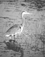
Using the grants in combination with matching landowner contributions, "We've accomplished about six million [dollars] plus in land conservation," said Ken Elowe, IF&W's Director of Resource Management. A decade of preservation Situated 17 miles/27 kilometers from the ocean, fed by six rivers, and draining a watershed of 9,500 square miles/24,600 square kilometers, Merry-meeting Bay is mostly fresh water, thanks to "The Chops" a land formation that pinches the mouth of the bay. At low tide, fresh water from the bay can move out into the Lower Kennebec, which flows from the bay to the ocean. But at high tide, The Chops prevent the rising river's brackish water from entering the Bay. The back-up of freshwater on the bay side of the Chops results in water level increases of up to six feet/two meters in the bay, creating freshwater wetland vegetation, mud flats, and sand bars that provide feeding and resting areas for waterfowl, and spawning areas for fish that swim upstream from the ocean. The Lower Kennebec River consists of more typical estuarine habitat with brackish water, tidal mud flats, and vast salt marshes representing more than 18 percent of the salt marsh in the state. The 9,000-acre/3,600-hectare system is critical year Ôround habitat for waterfowl as well as osprey, eagles, short-nosed sturgeon, piping plover, and least and roseate terns. "Primarily we've been seeking to protect the highest value wetland habitats," said Jack Witham of the Lower Kennebec Regional Land Trust. But, he said, "Because sometimes people are not willing to sell just a wetland parcel, but want to sell the whole piece, we often have to buy the upland habitat as well. That helps us create upland buffers around wetland habitat." Noting that land acquisitions can take years to complete, Bruce Kidman of TNC's Maine Chapter observed, "A lot of the spade work we're doing today will reach fruition a decade or two from now. We'll see the impacts on habitat protection for many years to come." Landowners' role essential "In order to get any [federal] funding at all, you need to have matching gifts of land and easements available," said Norden. "We really worked hard with our partners to begin outreach in these areas and see if there were landowners that might be interested in conserving their lands. Early on [TNC] received a generous gift of land. That, combined with easement donations to local land trusts, provided enough match for our first grant," she said. "Without cooperation and thoughtful and intelligent consideration by landowners, nothing would go forward," said Kidman. Granting easements or giving gifts of land may also make landowners eligible for tax relief or estate planning assistance. Easements can be custom-designed, according to Witham. "It can be everything from a forever-wild easement where no human intervention will take place at all, to a limited-development easement where you allow a certain number of houses to be built and no more," he said. Landowner participation is crucial to preservation in light of growing development pressures, said Betsy Ham, Executive Director of Friends of Merrymeeting Bay, noting, "Members of the aging generation are holding 100-plus acre tracts. When they pass on and next generation gets the land, we're not sure what will happen." Said Dale, "The conclusion I came to was, there better be a few unpopulated areas where people can come and just find solace. If not, I think that would be a horrible world to live in." |
||||||||||
 Woolwich, Maine - Bob Dale and his wife, Jean Parker, share their backyard with osprey, an assortment of waterfowl, foxes, deer - and a few porcupines and raccoons that don't hesitate to help themselves to Dale's fruit trees. For two decades, the couple has lived on a 40-acre/16-hectare island - a rugged chunk of paradise set down in the Sasanoa River's Brookings Bay in Maine's Lower Kennebec River region.
 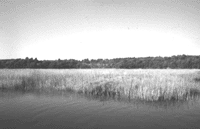 Typically, IF&W administers the grants and takes ownership of any land bought with the federal money. The land trusts retain any easements they negotiate, although those easements can be used to meet matching donation requirements for federal grants.