|
|
That’s reason enough to be concerned about them and monitor them, says Anderson. There are 240 seabird islands off the coast of Maine, but fortunately for Anderson, the largest known population of petrels lives on Great Duck Island. The island is located 12 miles off Bar Harbor. Anderson and his students decided to focus on the Great Duck petrels to find out why the birds chose the island, and to identify other habitats where the reclusive birds might live. And they’ve found a high-tech way to do their work without scaring the birds: an electronic sensor network that can unobtrusively collect important environmental data that can be beamed live via satellite to the Internet. The pilot network, installed in collaboration with Intel Research Laboratory at Berkeley and the University of California at Berkeley, potentially could be used for a spectrum of environmental monitoring, including whales and areas of sensitive vegetation. The Gulf of Maine Times recently interviewed Anderson about how the new technology used on Great Duck Island can help biologists better understand seabirds and their environment. Q. How did the project get started? A.
No one knows exactly how many petrels are there; the birds come onto islands
at night, live in burrows, and disappear for long times over the winter.
One of my graduate students spent two years trying to estimate the number
of petrels on Great Duck. She said there were about 9,000 pairs, plus
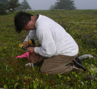
or minus 5,000. And there are hundreds of potential petrel islands. Most of the research done on seabirds has been done on birds that don’t mind being studied. But petrels live in a nice dark burrow and don’t like to be bothered. We’ve been studying them using a wire with a camera and infrared lights on it, a “petrel peeper,” that we’ve been feeding into burrows. Or you can simply stick your arm down the burrow and feel for feathers. But we needed to find a better way to learn about the birds without messing with them as much. Q. How does the sensor network work? A.
We use something called a mote, which is egg-sized. It includes the sensor
and microprocessor, a radio and battery. The built-in microprocessor can
be programmed so we can tell the mote what to do, for example, how often
to take a temperature or humidity reading. The sensors go on and off at
programmed times, and send their own data and data they have received
from other motes into a computer in the lighthouse, which then sends it
to a satellite linked to the Internet. It’s immediate. We don’t
have to wait months until we can get onto the island in the spring to
get data from the sensors. We have a grid across the island from east
to west, as well as up the island, both a foot above the burrows and inside
the borrows. Great Duck is about a mile long and a mile wide at its widest,
and it is about 200-feet high at its highest point, from which it tapers
to both sides. It is clearly a really good petrel island, but we still
don’t know why. We’re trying to collect as much information
about this island as we can and relate that to where the petrels actually
nest toward the center of the island. Q.
Have you learned anything interesting from the sensors so far? Q. When do you expect to have some conclusive data from the project? A.
I expect that within the next couple years we’ll be able to construct
a model and say that if we have this sort of soil and this sort of vegetation,
the chances are we’ve got a petrel island. Q. Do you plan to use more technology in the future? A. We’d like something that can be applied to aerial photography remote sensing so we can do a quick pass through the Maine islands and say certain islands are worth going to check because they probably have petrels on them. We’ve also talked about in the future putting a radio-frequency ID tag onto the birds so that when we tag the chicks, we can tell which bird is in a burrow, instead of the information we have now that a bird simply is in the burrow. A long-term hope is to have global positioning system (GPS) technology so we can keep tabs on the birds. It takes the chicks several years to mature, and we think they don’t come back for the first couple of years, that they stay out in deep water. Petrels also feed on plankton 200 miles out to sea for a few days at a time, and they disappear in the winter. But once they mature, they come back to the same burrow every year, so we could have a GPS receiver on them that records their location for the whole year, and then when they come back to the burrow at the beginning of a new breeding season it would automatically download that information to a mote. For more information, the Web site will start posting new data this spring: © 2005 The Gulf of Maine Times |