Core samples: Examining history to predict the future
By Susan Llewelyn Leach
Related stories:
Hurricanes: preparing for the next big one
*Web only content* Sensors, radar to give more details on hurricanes
 Hurricane activity in the Gulf of Maine is on the rise. But is it a temporary uptick or part of a decades-long, or even centuries-long, cycle? Scientists at Woods Hole Oceanographic Institution in Woods Hole, Massachusetts, are poking holes in the mud to try to find out. Hurricane activity in the Gulf of Maine is on the rise. But is it a temporary uptick or part of a decades-long, or even centuries-long, cycle? Scientists at Woods Hole Oceanographic Institution in Woods Hole, Massachusetts, are poking holes in the mud to try to find out.
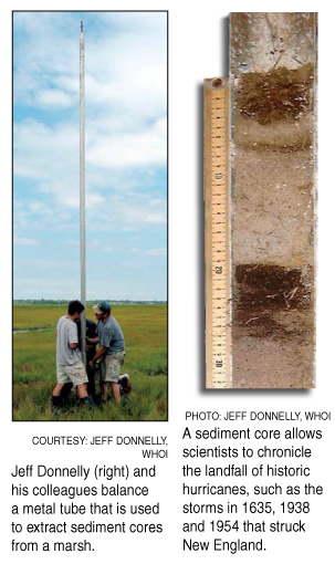
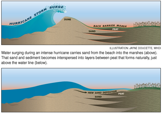
Using 20-foot (six-meter) long, vertical core samples from marshes and ponds, scientist Jeff Donnelly is piecing together a 2,000-year log of storm activity, which he hopes will offer clues to hurricane frequency in the future.
What’s surprised him in his research, he said, is the strong correspondence between the core sample sites in New England, the Caribbean and the Gulf of Mexico. The whole Atlantic basin is pulsing with the same storm cycles, he said. The intervals of frequent storms and the intervals of low activity are largely in step.
As for huge storms–Category 3 and above—they appear in the historic record about every 80 to 100 years. But the climate has been changing, and the impact that will have is unknown, Donnelly said. It may make the probability of a big storm even greater. Either way, “the probabilities will catch up with us,” he added.
In the meantime, the link between warmer seas and the present uptick is unconfirmed. Donnelly thinks a more critical factor in determining hurricane frequency in the Gulf of Maine will be the influence of global warming on El Nino and the West African monsoon.
His colleague Ilya Buynevich’s storm research goes back 5,000 years. The Woods Hole scientist, who is working in tandem with Donnelly, uses ground-penetrating radar to track old coastlines and ancient beaches. The radar acts like an X-ray, picking up concentrations of heavy minerals and steep dropoffs, which are subsurface signatures of a big storm. Then, using optical dating of the sand grains to measure when they last saw sunlight, he can pin the event down to within a couple of decades.
For coastal zone managers, this offers an insight into the shorelines’ shift, pointing to marching dunes and natural breakwaters that could guide future development.
In a couple of years, when their research is further along, Donnelly and Buynevich hope their data on how coastal ecosystems respond to huge landfalling hurricanes will guide coastal management and in turn limit damage, natural and human, from the next big one.
|