Resources
A new Fundy Issues Fact Sheet entitled Saving Special Places: Protected Areas and the Bay of Fundy,
written and designed by Jon Percy for the Bay of Fundy Ecosystem Partnership, explores the many
organizations and individuals that have protected particular areas in the Fundy region. The fact
sheet assesses federal, provincial, municipal and non-profit preservation efforts and their
effectiveness and calls for a coordinated and cooperative approach to protecting the Fundy
ecosystem. It is available at
www.bofep.org/fundy_issues.htm.
The U.S. Environmental Protection Agency has approved New Hampshire's request to designate its
coastal waters as a No Discharge Area. The designation applies to all of the state's coastal
waters, and means that discharges of treated and untreated boat sewage would be prohibited within
three miles of the shore. New Hampshire is the second state in New England to designate all of its
coastal waters as No Discharge. Thirty years ago, the state became the first in the country to
designate all inland lakes as No Discharge Zones. Other areas in New England with No Discharge
areas include all of Rhode Island's marine waters and Harwich, Waquoit Bay, the north side of
Nantucket, Wellfleet Harbor and Buzzards Bay in Massachusetts. To view the ôNo Discharge Areas
in New Englandö Web site go to
www.epa.gov/ne/eco/nodiscrg/index.html.
The U.S. Fish and Wildlife Service's Gulf of Maine Coastal Program and the Maine Atlantic Salmon
Commission have published the second edition of the Maine Atlantic Salmon Habitat Atlas. The atlas
has detailed maps of Atlantic salmon spawning and rearing habitats along 15 rivers in Maine.
The data were collected between 1994 and 2003. The second edition of the atlas is available in
PDF files and in ArcView Shapefile format for those with Global Information System (GIS) satellite
capabilities. PDF information for specific rivers can be viewed at
http://apollo.ogis.state.me.us.
Select ôMaps,ö then find the ôMaine Atlantic Salmon Habitat Map Series.ö GIS information is available
at http://apollo.ogis.state.me.us/catalog.
Select ôASHAB3.ö Click ôView metadata.ö For more
information on the salmon atlas contact Alex Abbott, c/o Gulf of Maine Coastal Program, U.S. Fish &
Wildlife Service, 4R Fundy Road, Falmouth, Maine 04105 or (207)781-8364.
The Coastal Issues Committee of the Nova Scotia Ecology Action Centre in Halifax has been conducting
tidal barrier audits around the Bay of Fundy since 2001. As part of this project, obstructions to
tidal waters and the effects on salt marshes and fish habitat were assessed and recommendations for
restoration were made. The results of these audits are now available on CD as a series of reports,
along with other relevant EAC publications. For information or to order a CD of these reports,
email tidalbarriers@ecologyaction.ca.
Municipalities, with help from land trusts, conservation commissions, historical societies and
others wishing to research forgotten or overlooked rights-of-way may apply to the Maine Coastal
Program for 2006 Right-of-Way Discovery Grants to help defray expenses. The grants are intended
to help communities find and assert public rights-of-way to the Maine coast that are in danger of
being lost by the passing of generations and changing land ownership patterns. The Maine Coastal
Program expects to provide recipients with technical support, in addition to funding. Individual
grants may not exceed $2,500. Applications must be received on or before January 3. For the
application guidelines and project description details, contact Lorraine Lessard at the Maine
State Planning Office (207) 287-1486 or at
Lorraine.Lessard@maine.gov. Information can be
downloaded from the Maine Coastal Program Web site at
www.maine.gov/spo/mcp.
ę 2005 The Gulf of Maine Times
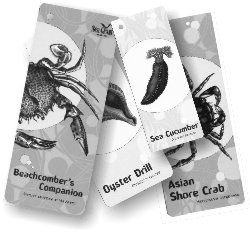 Beachcomberĺs Companionę, a project of the Woods Hole Oceanographic Institution Sea Grant
Program, is a new twist on the traditional field guide. Waterproof and portable, it features 50
brightly colored checklist cards of common Atlantic coast marine invertebrates, beautifully
illustrated (and scientifically accurate), and held together with a clip. Packaged in a mesh
collecting bag, each set comes with a special marking pencil for the checklist card, so every
critter you find on each trip to the beach can be recordedŚand wiped clean for next time. Cards
provide common and scientific names for each organism, along with classification information,
details on size, shape and color, and where to look for it. Fun and strange facts for each organism
are also included. Sets cost $16.95 US each plus shipping and can be ordered at
www.beachcomberscompanion.net/order.htm.
Beachcomberĺs Companionę, a project of the Woods Hole Oceanographic Institution Sea Grant
Program, is a new twist on the traditional field guide. Waterproof and portable, it features 50
brightly colored checklist cards of common Atlantic coast marine invertebrates, beautifully
illustrated (and scientifically accurate), and held together with a clip. Packaged in a mesh
collecting bag, each set comes with a special marking pencil for the checklist card, so every
critter you find on each trip to the beach can be recordedŚand wiped clean for next time. Cards
provide common and scientific names for each organism, along with classification information,
details on size, shape and color, and where to look for it. Fun and strange facts for each organism
are also included. Sets cost $16.95 US each plus shipping and can be ordered at
www.beachcomberscompanion.net/order.htm.