
|
Vol. 1, No. 4
Headline Back Issues Fall 1997
|
Ipswich River Watershed Association... (con'd) Parts of the Ipswich River bed lay dry as Kerry Mackin described the Ipswich River Watershed Association's (IRWA) 20-year effort to rescue the river from overuse and other threats. Mackin, the group's executive director, said the river's low water level was one of the main concerns prompting formation of the group in 1976. Interest in saving the river intensified in 1993 during a significant economic downturn in the town of Ipswich, location of IRWA's headquarters. "It offered the opportunity to say, let's turn the river into a cornerstone and central attraction of the downtown," Mackin said. The Ipswich River begins in Wilmington, Massachusetts, meanders 35 miles/56 kilometers through the northeastern part of state, and empties into the Atlantic at the southern end of Plum Island Sound. Water suppliers draw drinking water from the Ipswich for more than 300,000 people in 14 communities inside and outside the river's 155-square-mile/402-square-kilometer watershed. But most of the water withdrawn for public use is discharged outside of the Ipswich River basin by way of municipal sewerage systems instead of being recycled back into the Ipswich watershed. This, combined with seasonal changes in the river's water level, causes the Ipswich to frequently run dry in places, killing fish and causing other problems in the ecosystem. According to Mackin, dams along the river have also blocked migration of anadromous fish to and from the ocean since the 1800s. In attempting to make the river healthy again, IRWA collaborates with numerous groups to develop public education campaigns, land protection priorities, and other efforts. In 1996 IRWA formed a task force at the suggestion of water suppliers to find the causes of the low flow problem, and to recommend to state and federal agencies ways of promoting a healthy river ecology while allowing diverse uses from recreation to wastewater assimilation. The task force includes water suppliers; municipal, state, and federal officials; environmental groups; sporting organizations; and businesses. Businesses were eager to participate, Mackin said, because "The regional water supply is absolutely critical to the stability of the region's economy." Some companies have cut their water use by more than 75 percent, conserving resources and lowering their own costs, she noted. IRWA also helps communities repair leaks in their distribution pipes, and campaigns aggressively for the public to conserve water. "Everyone has the potential to live just as well using less water. It need not be a lifestyle choice," said Mackin.
Along with member donations, funding for IRWA's work comes from grants, such as one from the Gulf of Maine Council on the Marine Environment to study the effects of animal waste on the river. Private sources and state agencies, such as Massachusetts Coastal Zone Management, have also provided grants, and the Massachusetts Division of Marine Fisheries recently donated staff time and expertise to repair a fish ladder on a dam in downtown Ipswich to encourage blueback herring to return to their spawning grounds, said Mackin. Last spring, the Washington, DC-based environmental group, American Rivers, named the Ipswich one of the most threatened rivers in the US. But while problems like low water levels continue, Mackin said cooperation among diverse interests, and the willingness of state agencies to refine some of their procedures, is helping IRWA's work progress. "Regulatory difficulties exist, but we've made some improvements" in researching and restoring the river's health, she said. Merrimack River Watershed Council
Instead, the council helps communities collect, interpret, and act on information about their own tributary of the Merrimack."We engage the folks who live and work in a sub-watershed" of the Merrimack River watershed, helping them understand how their actions affect the resource's health, he explained. The Merrimack River watershed begins in Franconia Notch, New Hampshire, where the Pemigewasset River originates. The Pemigewasset converges with the Winnepesaukee 60 miles/97 kilometers south in Franklin, forming the Merrimack River, which travels another 116 miles/187 kilometers to the Atlantic at Newburyport, Massachusetts. The 5,010-square-mile/12,976-square-kilometer watershed encompasses 17 smaller sub-watersheds and 204 municipalities in Massachusetts and New Hampshire, though 75 percent of the watershed lies in New Hampshire. The council has offices in both states. According to Laffin, the MRWC emerged 20 years ago out of a "huge national interest in water and rivers" that developed following passage of the US Clean Water Act in 1972. The river had played an important role during the industrial revolution, but suffered severe pollution as a result, coming to represent a problem rather than a point of pride for the communities on its banks. "It wasn't too long ago that people were turning their backs on the river, literally," said Laffin. But a combination of federal regulations and community interest have changed that attitude. "We've done a pretty good job of cleaning up the point sources via wastewater treatment plants and industrial pollution controls," Laffin said. The turnaround has prompted the council to nominate the Merrimack's mainstem for designation under the President's new American Heritage Rivers program. Nevertheless, as with rivers throughout the Gulf of Maine watershed, nonpoint source pollution entering the river through runoff and underground leaching from gas stations, pesticide-treated lawns, leaky septic systems, automobiles, animal waste, and other sources remains a threat. MRWC devotes substantial effort to convincing people that it's not federal regulations that will cure these problems, but their own attentiveness to what they do in their driveways, neighborhoods, and communities.
Businesses located in the watershed, such as Raytheon, Anheuser Busch, and Watts Regulator, have supported MRWC's efforts with membership dues, and by funding specific projects and encouraging their employees to join in projects. Noting that citizens have been eager to help with water quality sampling programs, Laffin said, "People want to protect their water resources, they just don't always know how to do it" until an organization like MRWC provides guidance and training. Planning Alliance for the Damariscotta River Estuary, Damariscotta River Association, Damariscotta Lake Watershed Association Descending from a lake and wandering 16 miles/26 kilometers through seven mid-coast Maine towns before emptying into the Atlantic at East Boothbay, the Damariscotta River has inspired several complementary stewardship efforts. Planning board representatives from each of the seven towns within the river's 103-square-mile/267-square-kilometer watershed direct the activities of the Planning Alliance for the Damariscotta River Estuary (PADRE), said Executive Director Tom Ford. Based in the town named for the river, PADRE formed at the recommendation of the Damariscotta River Estuary Project, which was created by the Maine State Planning Office in 1993 and modeled after the National Estuary Project "but on a more grassroots level," said Ford. Though he described cultivating collaboration among the communities and equitably addressing their concerns as challenging, Ford noted that PADRE is making progress. "Bringing together seven communities who traditionally have taken a very parochial view...trying to change that mind set has perhaps been its best accomplishment and I think in the long run will probably be one of the more lasting legacies that it could leave to this area," he said. PADRE survives on "modest financial support" from its member communities, and funding from grants and foundations. It undertakes some joint efforts with state agencies, making use of in-kind services they provide. Using a grant from Maine's State Planning Office, PADRE is helping municipalities address factors that can affect estuarine health, such as leaky septic systems. A grant from the Gulf of Maine Council on the Marine Environment has supported efforts to reduce plastic debris in the estuary. Other grants fund campaigns to reduce nonpoint source pollution in communities and at marine facilities and to improve water quality in the river's Great Salt Bay polluted by a nineteenth century match factory and foundry so it can be opened to aquaculture and shellfishing. The bay separates the freshwater Damariscotta Lake from the saltwater river, serving as the estuary's headwaters. Ford said PADRE's success is largely due to its close communication with citizens and municipal officials. The planning group also stays in touch with the two other well-established stewardship groups in the watershed, the Damariscotta River Association (DRA) and the Damariscotta Lake Watershed Association (DLWA). A conservation organization and land trust, DRA works with state and federal agencies, landowners, businesses, and other interests to protect the Damariscotta River Estuary, its watershed, and adjacent areas. Its 40-member citizen water quality monitoring effort, Tidewater Watch, has tracked the river's health for a decade, said executive director Peter Knauss from his Damariscotta office. The Damariscotta Lake Watershed Association collaborates with state agencies and the Damariscotta River Association to inform the public about the lake watershed ecosystem especially about nonpoint source pollution in the river's freshwater source. According to DLWA president Al Railsback, who lives in Nobleboro, one of the towns bordering the lake, "We have the dubious status of being one of Maine's lakes most at risk of development." However water quality monitoring efforts garnered a Lake Conservation Award from Maine's Congress of Lake Associations in 1994. Membership dues and fundraising proceeds support the groups's work, said Railsback, adding, "We want to protect the lake as property owners, but also we need to do more than just worry about our little piece of turf here. We're looking for a way to complete the map, because we are a part of the overall watershed." Tusket River Environmental Protection Association
Nickerson and 52 other concerned neighbors launched a lobbying effort that eventually pressured the mine to change its practices, including treating the grinding liquid before discharging it. More than a decade later, the group continues to meet to, among its other activities, keep an eye on reclamation of the now-closed tin mine. The Tusket River originates near Weymouth, Nova Scotia, and meets the Atlantic 50 miles/81 kilometers southwest at Wedgeport, south of Yarmouth. Its watershed covers 1,000 square miles/2,590 square kilometers. A volunteer organization that is supported by membership fees and fundraising proceeds, TREPA often works with other groups on watershed stewardship or education projects. A grant from the Gulf of Maine Council on the Marine Environment funds an environmental display sponsored by TREPA at a Yarmouth shopping mall. The Collaboration for Community Foundations provided funding for the group to educate intertidal fishermen on the benefits of organizing, resulting in formation of the Intertidal Harvesters' Coalition. In partnership with the Nature Conservancy of Canada and Bowater Mersey Paper Company, which donated 26 acres of lake shore to TREPA, the group is protecting a rare coastal plains plant species, Plymouth Gentian, which grows on the donated land. TREPA also lobbied successfully for installation of a new fishway at Tusket Hydroelectric Dam by Nova Scotia Power, Nickerson said, citing a resulting increase in the numbers of anadromous fish in the river. To help residents of the Tusket watershed's small, rural towns to understand and take care of their river, the watershed organization also sponsors summer nature walks and sends speakers to schools to talk with students about the watershed. Concerns about the tin mine's effects on the river, as well as the potential effects of acid rain, prompted the group to establish volunteer water quality monitoring teams, as well. "It began because people cared," said Nickerson of his group. "When there is a major crisis, people rise up. When that crisis disappears, people often fade into the background." But despite a certain amount of burnout common among grassroots groups, Nickerson said a dedicated core of volunteers has kept the TREPA focused and active. Petitcodiac Watershed Monitoring Group, Petitcodiac 2000 Neighbors of the Petitcodiac River are broadening their concern for the river beyond its controversial causeway. Two relatively new groups, the Petitcodiac Watershed Monitoring Group (PWMG) and Petitcodiac 2000 (P 2000) are setting out on a more comprehensive approach to addressing the health and management of the river's 690-square-mile/1,786-square-kilometer watershed. The Petitcodiac River flows through southeastern New Brunswick from Anagance approximately 49 miles/79 kilometers to Upper Shepody Bay in the Bay of Fundy. The river has been a painfully contentious feature of the landscape since the construction 30 years ago of a causeway traversing it to link the communities of Moncton and Riverview. Some say the causeway, built with five gates to regulate the river's tidal flow, is killing the Petitcodiac's ecosystem and blocking fish migration, because the gates are mostly closed. They favor restoring the river to a free flowing tributary. Others argue that opening the gates and draining the head pond above the causeway would destroy an equally valuable ecosystem and recreational resource, and could cause problematic erosion. The province plans to open one of the gates on an experimental basis next spring. Based in Moncton, PWMG worked hard its first year to stay clear of this issue, instead gathering and testing water samples, and educating communities about the river's water quality, according to coordinator Sandra Cashin. P2000, also Moncton-based, formed last spring to study and make recommendations to the provincial government regarding issues affecting the river's health, including but not limited to the causeway, according to Chairman John Legault of the Habitat Management Division of Canada's Department of Fisheries and Oceans. Though still establishing themselves, PWMG and P2000 represent a much different approach to addressing concerns about the river than the predominantly adversarial one of the last 30 years. But those involved won't yet characterize the shift as a community-wide cooperative effort. "People are still sitting at the table and talking with each other. There is some venting of frustrations at different factions at those meetings, but it stays fairly civil we're just trying to get at common objectives," said Julia Chadwick, a steering committee member for both organizations, and an organizer of Friends of the Petitcodiac, a coalition of Moncton-area advocacy groups who favor reestablishing the river's free flow. According to Chadwick, the biggest difficulties in addressing Petitcodiac watershed issues have been defining which groups will handle which issues, transcending the causeway controversy to develop a broader approach to the river's health, and a lack of water quality data. PWMG is responding to this last factor. "We have successfully initiated water quality monitoring at 40 sites in the Petitcodiac watershed," said Cashin. During last year's effort, more than 50 trained volunteers collected samples every two weeks, launching the beginning of a database, she said. But while environmental organizations, community groups, sporting organizations, the University of Moncton, and provincial and federal agencies have paid for test kits, or donated lab services, Cashin said PWMG's limited finances won't support a full time staff person, and this made the program's first year an "exhausting" one. It was successful, she said, thanks to "dedicated and committed volunteers." For information on watershed stewardship Global Rivers Environmental Education Network New England Interstate Water Pollution Control Commission River Network Riverwatch Network Learn about your own watershed at the USEPA Index of Watershed Indicators |
||||||||||
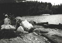 Volunteers participate in water quality monitoring efforts and on "Stream Teams" groups of activists who organize riverside cleanups and guided walks along dry sections of riverbed.
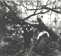 "You can't clone programs for watersheds," which differ widely in their geography, politics, and culture, emphasized Curt Laffin, project manager for the Merrimack River Watershed Council (MRWC). "We don't go into any sub-watershed and say, This is what you ought to do.'"
 MRWC coordinates the efforts of community residents, businesses, and government agencies to protect and promote the large watershed. It plans broad efforts, such as the Merrimack River Initiative a comprehensive watershed management plan, and helps to coordinate river cleanups, volunteer water quality monitoring, and guided canoe trips.
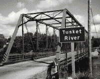 In 1986, residents along the Tusket River were alarmed to notice that its water had turned brown. A tin mine had been using the river as a dump site for untreated liquid from its grinding operation and, "They were attempting to use straw to catch the silt, if you can believe that," recalled Mil Nickerson, fundraising vice president for the Yarmouth-based Tusket River Environmental Protection Association (TREPA).