Indicators: taking the environment's vital signs
Printer Friendly Page
By Cathy Coletti
Wearing chest waders and neoprene gloves, Beth Lambert detached a blue mussel from rocks in shallow water and placed it in a mesh bag. She stopped to warm her hands.
“People usually eat mussels,” Lambert, coastal restoration coordinator with the New Hampshire Coastal Program at the New Hampshire Department of Environmental Services (NHDES), said as she adjusted her fleece hat against the wind. “But we're using them as indicators to tell us about the health of the ecosystem.”
 |
| CLICK ON IMAGE TO ENLARGE |
Lambert is not alone. From the Bay of Fundy to Cape Cod, participants in Gulfwatch, a chemical-contaminants monitoring program, all collected and shucked blue mussels on the same day using the same methods, and all in the name of indicators. The Gulfwatch program annually monitors the concentrations of toxic contaminants in blue mussel tissue in the Gulf of Maine watershed.
“A sense of humor is a must have,” said Natalie Landry, from the Watershed Assistance Program at NHDES and another Gulfwatch participant, who's unable to eat mussels for months following the collection. “They just aren't appetizing; they no longer look like food, they just look like a science project!”
Comparing apples
An indicator is a measurement that shows what environmental conditions are like now and how they are changing over time. Since 1993, Gulfwatch has measured contaminants in blue mussels (Mytilus edulis) to assess the types and concentration of contaminants in coastal waters of the Gulf of Maine. Gulfwatch is coordinated and conducted by scientists and managers from agencies and universities around the gulf. The program operates under the guidance of the Gulf of Maine Council's Contaminants Monitoring Committee. It is one of the few monitoring programs and the only one in the Gulf of Maine to be coordinated across international borders.
Unlike the Gulfwatch program, many organizations collect indicators as stand-alone programs and have limited communication and collaboration with other groups. As a result, decision makers often receive environmental reporting that can't be compared, shared or used to determine the condition of the overall health of the watershed, said Ray Konisky, former program manager for the Ecosystem Indicator Partnership, or ESIP, a Gulf of Maine Council committee that was elevated from a work group to a formal committee in June 2006. Konisky started a new position with The Nature Conservancy in January and will pass the torch to a new manager. As of this writing, a replacement has not been selected.
ESIP got its beginnings as an informal work group in 2002. “The group was formed to discuss developing specific indicators to measure and determine the state of the Gulf of Maine, from the health of ecosystems to understanding human impacts on the health of the gulf,” said Susan Russell-Robinson, co-chair of the ESIP Committee and scientist with the U.S. Geological Survey.
ESIP is now organized as a standing committee of the Gulf of Maine Council. There are now six subcommittees working on the following indicators: coastal development, contaminants and pathogens, eutrophication, aquatic habitat, fisheries and aquaculture, and climate change. There are about 40 people involved in the subcommittee activities.
Sharing data
ESIP is currently bringing together people, monitoring data and technology to come up with a way to report indicators data that can be easily shared between groups.
“Indicators give us a tracking system, a way to see where we are now and how it's changing,” said Konisky.
The potential users of a regional indicators reporting system are as varied as the flora and fauna in the Gulf of Maine: boaters, surfers, commercial fishermen, resource managers, municipal leaders, and university researchers, to name some. The data supplied by indicators can be used to assess, protect and restore regional habitats, compare trends to determine if conditions are getting worse, better, or staying the same, and bring science into play when making decisions.
| "An indicator is a measurement that shows what environmental conditions are like now and how they are changing over time. " |
Crossing two Canadian provinces and three states, the Gulf of Maine watershed includes many personalities, opinions, intellects, and nonprofit and government entities, often working alone on managing contaminants that know no boundaries. There are at least 100 programs that do monitoring work in the Gulf of Maine watershed, ranging from weather stations collecting temperature data to organizations studying salinity levels and fish populations at restoration sites, according to Konisky.
“That's a lot of different groups to get together and agree on how to share and use data,” Konisky said.
On a regional scale, indicators take on a more powerful meaning. Like an annual doctor's visit, regional indicators look at trends in the condition of the entire body, or in this case watershed, by looking at separate factors that could indicate trouble looming in the future. Elevated cholesterol in blood could lead to heart failure later. Trends in contamination might mean the ecosystem is being overloaded by pollutants that could adversely affect many of its inhabitants, including humans, in the future.
Online data
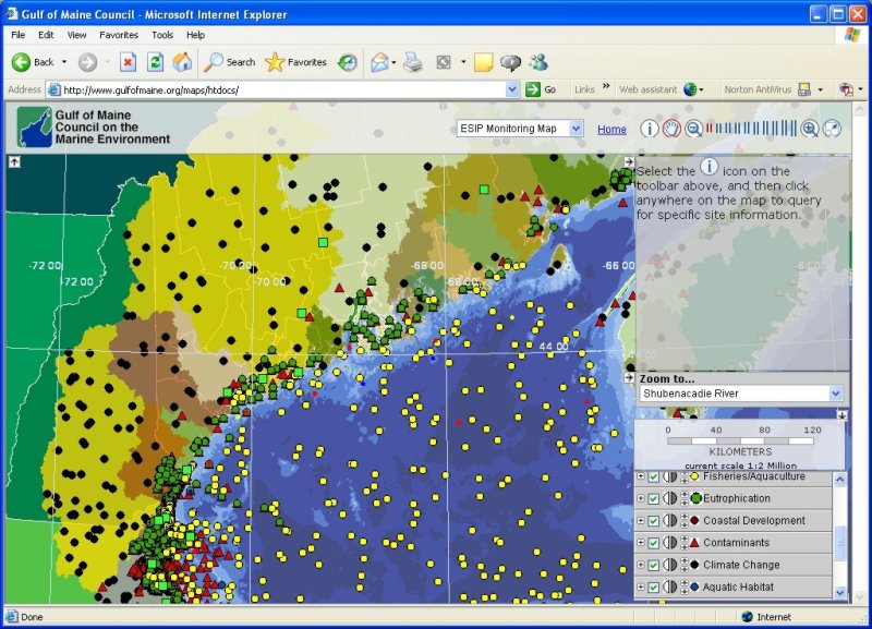
Last October, the ESIP released a gulf-wide online map that displays existing monitoring sites for five of these six indicators (coastal development will be incorporated later). Users can view the location of monitoring sites for each category and customize their view by adding or removing layers of data. Some information on each monitoring site is included, such as the name of the monitoring organization, the type of data being collected and a latitude and longitude reading. Currently, the actual data measurements are not listed.
One of the most valuable aspects of the monitoring map may be that it can help make programs aware of others collecting similar data in a format that can be accessed online rather than a hard copy report collecting dust, Konisky said. For instance, a researcher at the University of Maine might find out that the Environmental Protection Agency is also collecting data on nutrient loading in the same vicinity. Contact information is also just a click away, making it easier to communicate.
The biggest concern about the map has been the slow speed of downloading the large amount of information, which includes about 9,000 sites, with more to be added. This first stab provides a framework from which to build on. It is intended to be constantly updated, making it a dynamic and ever-changing tool, Konisky said.
“Without the framework, there would be no base to improve,” he added.
The next step in the evolution of the monitoring map is incorporating the results of the indicator measurements into the system. In addition, ESIP will keep expanding map coverage to include other monitoring programs, and more feedback from users will be collected.
Other products of ESIP include two reports: the Gulf of Maine Indicators Listening Sessions and Evaluation of Tides of Change Report at http://www.gulfofmaine.org/esip/docs/esiplistening.pdf, and the Strategy for Gulf of Maine Ecosystem Indicators and State of the Environment Reporting at http://www.gulfofmaine.org/esip/docs/esipstrategy.pdf.
For more information about ESIP and a link to the monitoring map visit www.gulfofmaine.org/esip/ For more information on the 2004 Indicators Workshop, visit www.gulfofmaine.org/nciw.
Cathy Coletti is assistant editor of the Gulf of Maine Times and writes about environmental issues.
© 2007 The Gulf of Maine Times