
ResourcesIdentification of Important Habitats in Coastal New HampshireChapter 20. Atlantic SilversideThe Atlantic silverside, Menidia menidia, is a small relatively
common inshore fish of the mid-Atlantic coast. Silversides school in shallow
estuarine waters, and are an important prey of larger fishes and birds.
They are used as bait in marine recreational fisheries. The following
tables are components of a model to map silverside habitat. Most of the
information was derived from Fay et al. 1982 and Bigelow and Schroeder
1953. The resulting habitat scoring (suitability index values) was adjusted,
based on conditions occurring at collection sites in coastal New Hampshire
at which silversides were relatively abundant. Collection data were obtained
from New Hampshire Fish and Game (Nelson et al. 1981), Normandeau Associates
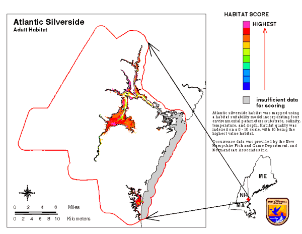
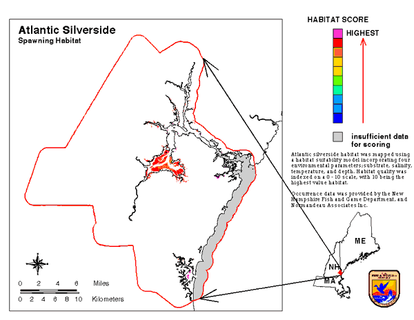
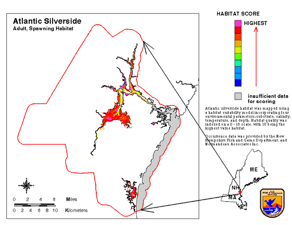
1974, and Normandeau Associates 1995. The model operates on four parameters: substrate, salinity, temperature,
and depth. The model indexes the relative suitability of each environmental
parameter on a 0 to 10 basis, with 10 being optimal and 0 being unsuitable.
These suitability index values are combined by computing their geometric
mean for each grid-cell in the study area. Thus, optimal habitat for any
life stagewould occur where the index values were the maximum for each
of the four inputs; no value is attributed to areas where any condition
is completely unsuitable. Silversides typically leave estuaries in winter,
so suitability was calculated for spring, summer, and fall conditions.
Habitat values for the adult stages were computed as the average for the
three seasons, while reproductive habitat was defined from the most favorable
of either spring or summer conditions. Overall habitat was mapped from
the maximum score for either adult or reproductive stages (Figures
of; Adult Habitat, Spawning
Habitat, Combined Life Stages). SUBSTRATE PREFERENCES Substrate Suitability Index: 0 to 10 scale; 0 = unsuitable, 10 = optimal condition ADULT
SPAWNING
SALINITY PREFERENCES Salinity (ppt) Suitability Index: 0 to 10 scale; 0 = unsuitable, 10 = optimal condition ADULT
SPAWNING
TEMPERATURE PREFERENCES Temperature (C) Suitability Index: 0 to 10 scale; 0 = unsuitable, 10 = optimal condition ADULT
SPAWNING
DEPTH PREFERENCES Depth (feet, mlw*) Suitability Index: 0 to 10 scale; 0 = unsuitable, 10 = optimal condition ADULT
SPAWNING
* mean high water approximately +8' |