
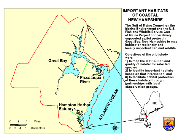
ResourcesIdentification of Important Habitats in Coastal New HampshireChapter 1. Summary of the AnalysisSelection of Study Area BoundariesEarly in the analysis, it became apparent that selection of the study area boundaries must be affected by political, social and ecological considerations. We had to include areas of interest to local conservation activists, include complete governmental jurisdictions, and include areas affecting or protecting critical marine resources. The initial proposal was for analysis of Great Bay, New Hampshire. Upon consultation with local conservation and scientific interests (Great Bay Resource Protection Partnership, New Hampshire National Estuary Project, Jackson Estuarine Research Laboratory) this was expanded to cover the waters and contiguous towns of Great Bay and Little Bay, their tributaries to the head of tide, and the Seabrook/Hampton estuary. To assure adequate consideration of resources near town borders, the study area boundary was drawn to include a 1 mile buffer zone around the towns (Figure of Study Area). Selection of Evaluation SpeciesOne of the purposes of this pilot study is to establish methods for using the list of high priority species identified by the Habitat Panel for the GOMC. The list (Appendix A) contains 161 species, each assigned a numerical score based on carefully drawn criteria. The proposal for this pilot study suggested that the highest scored species from the list should be selected as candidate evaluation species. As a practical matter, it was estimated that an analysis could be performed within the time and cost constraints for about 12 to 20 species, and that this number of "Great Bay species" might be found among the top 30 of the GOMC list. To insure that priorities of local conservation interests were considered, we proposed adding 3 locally important species to the list of regionally important species. We consulted with local experts from conservation organizations, agencies, and the University of New Hampshire to select evaluation species from the top increment of the GOMC list, and to nominate species of local interest. The responses were highly significant: there was only limited local interest in the designation of regionally significant habitats, and many locally interesting species were recommended. However, the experts did regard the top scored species of the GOMC list as locally important, and a majority of their candidates were also on the GOMC list, but ranked below the top 30. As a result, we produced a longer list of evaluation species than intended. These, however, could be aggregated to identify both regionally important and locally significant habitats. The rationale for selecting species, whether of local interest or from the GOMC list, was that they meet either of 2 criteria: 1) the study area is likely to serve as important habitat for the species; 2) the species is regarded as important in the study area. The former category may include even uncommon species which rely on study area for some essential resources; the latter may include species which are also abundant elsewhere, but which are important as prey, predator, structure, or are of recreational or commercial significance within the study area. The evaluation species are presented in Table 1. The GOMC score was assigned by the Habitat Panel, and ranged from 18 to 66 for the 161 species. Table 1. Evaluation Species For The Great Bay Pilot Project
Methods for Identifying HabitatsIdentification and mapping of habitats for the evaluation species requires the interpretation of data on the occurrences of each species, often by life stage, and may require appraisal of the environmental aspects of areas typically occupied. Habitats may be mapped by:
In general, highest level of confidence can be claimed by the first method, although important habitat components may be overlooked in areas that are difficult to sample. Observations are not transferable to new sites. In contrast, models may be applied throughout the range of the species characterization, providing basic environmental data are available. The level of confidence in a model must depend on the quality of those data and of the biological data and understanding that went into the model. Expert opinion is of highly variable accuracy; it suffers from limited documentation; local knowledge is not directly transferable to new sites. It is important to note that suitable habitats, whether mapped from past occurrences, by modeling, or expert opinion, may not be consistently occupied by the species of interest. Scoring of HabitatsThe habitat analysis was conducted in 2 stages; 1) mapping of occurrences or of locations having suitable conditions for each species, including an estimate of habitat quality, and 2) combining habitat maps for the species, adjusting for the relative importance of the species or the relative scarcity of its habitat(s). Mapping Habitats by SpeciesOur maps were created using a geographic information system (GIS), with which we analyzed and overlaid digital spatial data (coverages). The analyses used methods 1 and 2, or combinations of the two, depending on the availability of information (see Table 2). Table 2. Methods Used for Mapping Habitat, and Basic Spatial Data
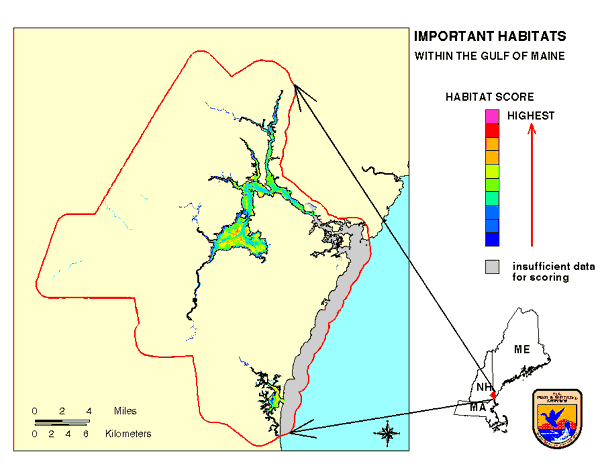
We first obtained information on occurrences or habitat requirements and associations for each species from the scientific and technical literature, and from local experts. We then digitized the occurrence information or operated models to produce coverages in which areas were assigned scores as estimations of their "habitat suitability" for each evaluation species. Habitat suitability (USFWS 1980) is a numerical representation of the ability of an area to support at least some life stage of the species; relatively higher suitability values indicate potential for greater population density, reproductive success, growth rate, survival, etc. Suitability models may predict the level of use of a habitat, and field sampling and surveys can be used to test or validate a model. While we did not have sufficient data for statistically testing our models, we did overlay available sampling data on habitat maps generated by the models to allow visual comparison. We adjusted the models to best fit the published relationships and the local distribution of the species. While suitable areas may not, in fact, be occupied because of population dynamics or because other factors are limiting, unsuitable areas should typically exhibit little usage by the species. Draft habitat suitability maps were plotted, including narratives on all life stage components of the models, how these were combined, and the available occurrence information. Local experts then reviewed these maps, and used their knowledge (method 3) as 'collateral data'. We also distributed description of the models for review by local and other experts. Only final maps of aggregated life stages are presented in this report; the intermediate information is archived at the Gulf of Maine Project. Habitat suitability ultimately was indexed on a 0 to 10 basis, lowest to highest habitat value. Where occurrence information was used directly to create digital maps (e.g., for marine algae, cordgrass, bald eagle) the suitability of these sites were recognized by giving them a score of 10. Maps created by the operation of models on environmental data layers had a range of values according to the relative suitability of each layer. Habitat suitability was considered by life stage and by season for many of the species. When combining suitability maps for these stages and seasons we took into account their probable interdependence. For example, mobile species such as fishes and birds may migrate when local habitats become seasonally unsuitable. In such cases, when potential use during one season is independent of value during other seasons or value to other life stages of the species, the habitat score for an area should reflect the most favorable conditions which occur during the year. This was expressed by calculating the maximum of the habitat suitability values among the seasons examined. On the other hand, plants or sedentary animals such as mussels, oysters, or clams are exposed to the entire range of conditions occurring within that area during the year; for these species habitat suitability may best be represented by a combination of seasonal values, or even the minimum or most stressful set of conditions. Habitats which were relatively specialized and scarce (e.g., spawning habitats for some fishes) were combined with coverages for other life stages by using a maximum function, to insure the recognition of highest habitat valuation. The specifics of mapping are described in the narrative for each species, and links are provided to figures showing habitat suitability maps for various life stages. Combining Habitat Maps for Groups of SpeciesThe digital habitat maps were aggregated in two ways; to identify regionally important habitats and to identify locally important habitats. The former incorporated, in addition to habitat suitability, a measure of each species' importance derived from the GOMC criteria. Application of the criteria produced a set of scores based on characteristics of each species. Habitat for the highest scored species on the GOMC list was regarded as more important than equivalent habitat for a species with lower score. These scores were, in fact, used to index the values for the final map of regionally important habitats. Since local interests expressed little enthusiasm for the regional importance of the species, this index was not applied when producing maps for local conservation purposes. The map of regionally important habitats was created from habitat maps for the top ranked GOMC species (Figure of Regionally Important Habitats within the Gulf of Maine). We indexed their GOMC scores (see Table 1) on a 1 to 10 basis, then multiplied their habitat suitability values by that index and added the products on a cell by cell basis. The index values represent the species' scores in relation to the full range of scores for the GOMC list (18 to 66); they are presented in Table 3. Table 3. Index Values Representing Regional Importance;
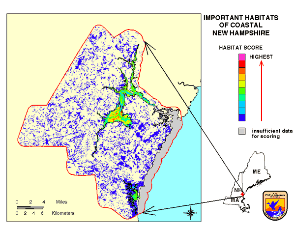
The relative abundance of habitats or habitat components is generally of concern to conservationists, and was actually a ranking factor in creation of the GOMC list. Abundance or scarcity is related to risk; the impact on great blue herons, for example, from loss of one acre of nesting habitat is almost certainly more severe than from loss of one acre of the far more abundant feeding habitat. Local abundance or scarcity of habitat(s) was regarded as relevant to the local importance of habitats. It is not proportional to regional abundance, and so this factor was not used for creating the regional map. To map locally important habitats (for all species, since the GOMC species also were regarded as locally important), we multiplied the habitat suitability values by an index representing the respective relative scarcity of each habitat within the study area (Figure of Important Habitats within Coastal New Hampshire). This was calculated from the extent of habitat for each species or stage, divided by the extent of the most abundant habitat. Relative scarcity was calculated by life stage or habitat function, where more than one of these was mapped (e.g., reproductive, juvenile, and adult habitats for some fishes; multiple habitats for black ducks). Thus, relatively rare habitat components could be highlighted, even where the overall habitat for a species might be extensive, or where some components were not mapped for all species. This index, also on a 1 to 10 basis, is enumerated in Table 4. The products (scarcity index times habitat suitability values) were summed on a cell by cell basis. Table 4. Index Values Representing Relative Scarcity
of Habitats;
|
|||||||||||||||||||||||||||||||||||||||||||||||||||||||||||||||||||||||||||||||||||||||||||||||||||||||||||||||||||||||||||||||||||||||||||||||||||||||||||||||||||||||||||||||||||||||||||||||||||||||||||||||||||||||||||||||||||||||||||||||||||||||||||||||||||||||||||||||||||||||||||||||||||||||||||||||||||||||||||||||||||||||||||||||||||||||||||||||||||||||||||||||||||||||||||||||||||||||||||||||||||||||||||||||||||||||||||||||