
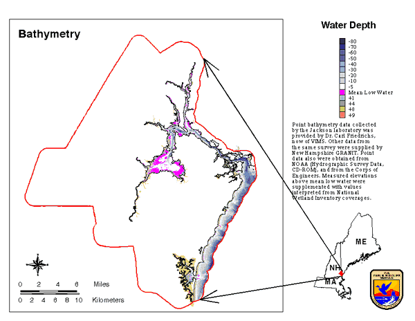
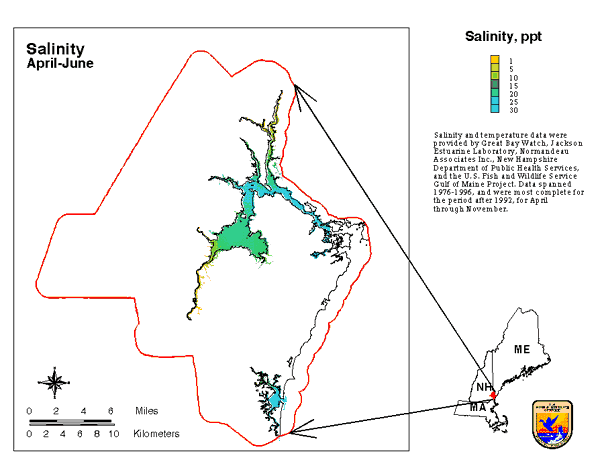
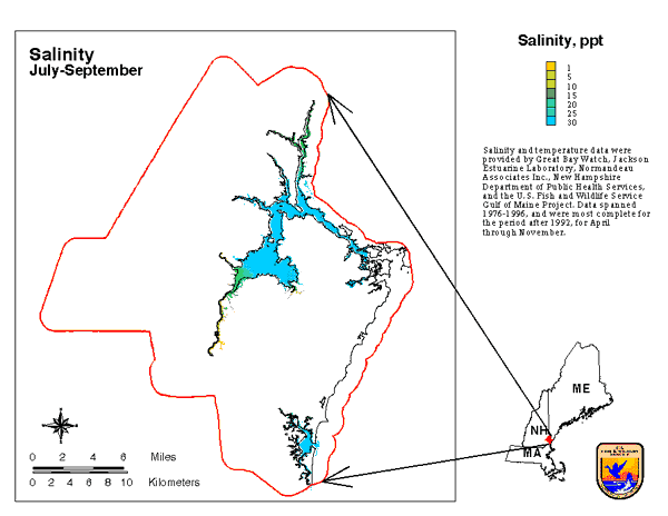
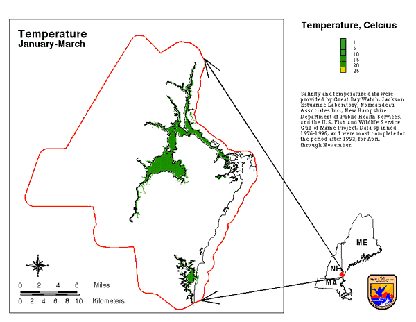
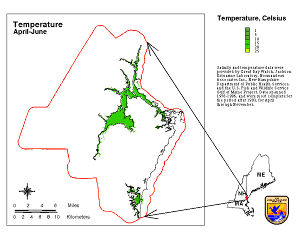
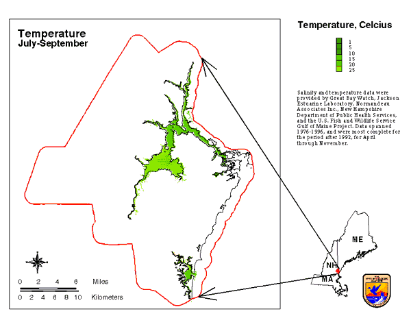
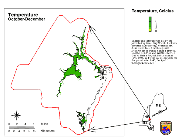
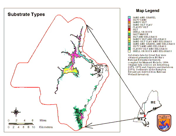
ResourcesIdentification of Important Habitats in Coastal New HampshireChapter 2. Environmental ThemesCertain environmental data sets were used as base maps or layers when modeling habitats, or to delineate occurrences as habitats. These include bathymetry, temperature and salinity, and substrate of coastal waters. Landcover and vegetation maps also were essential for this analysis; these are described in the following sections. BathymetryBathymetry information is particularly critical for modeling habitats of coastal organisms. While many fishes and invertebrates have preferences and limitations regarding water depth, it is the actual exposure and submergence of intertidal habitat which controls the penetration of land-based and marine plants and animals into the adjacent domain. The location and extent of this intertidal zone is based on bathymetry and tide range. A GIS bathymetry coverage of Great Bay and Little Bay was obtained from New Hampshire GRANIT. This had been based on a survey by the Jackson Estuarine Laboratory. It was found that, in processing the original point data, locations were generalized, and thus the coverage accuracy considerably degraded. We were able to replace the processed values for Great Bay with the original point data, obtained from Dr. Carl Friedrichs of Virginia Institute of Marine Science. An extensive series of sounding was obtained from the U.S. Army Corps of Engineers for the Piscataqua River and for Hampton Harbor. Point data also were obtained from NOAA (Hydrographic Survey Data on CD-ROM) for all of coastal New Hampshire. We digitized contour lines from NOAA charts to supplement the point data, particularly along edges of tributary channels. Bathymetric data was lacking for the head of tide portions of the Salmon Falls and Squamscott Rivers, for Sagamore Creek and for Spinney Creek; aerial photos show subtidal conditions for these areas, and so they were arbitrarily designated -3' mean low water (mlw) in depth. Few soundings were available for intertidal areas, particularly approaching the elevation of high tide. As an estimate of bathymetry for nearshore areas we interpreted shoreline and marsh attribute information from National Wetland Inventory (NWI) digital maps. Mean high water for Great Bay is between +7 and + 8 feet, mlw. Therefore, NWI polygons designated as upland were assigned an elevation of +10 feet mlw; freshwater marshes contiguous with tidal waters were given a value of +9'; irregularly flooded salt marsh was assumed to be + 8 feet (at and above mean high tide), regularly flooded ("low") marsh was assigned an elevation of +4 feet. This NWI interpretation was used to "mask" the irregular outer boundary of the interpolated data. The combined point and line data were used to generate a triangulated irregular network (TIN) in ARCINFO, and the TIN used to create a lattice (grid-cell coverage). The lattice was created with the same cell dimension (93.493 feet) as the GRANIT landcover grids, for all tidal waters within the study area. Depths were calculated as integer values in feet below mean low water (Figure of Bathymetry). Temperature and Salinity of Coastal WatersTemperature and salinity levels are important in determining the distribution of estuarine and marine fishes and invertebrates. We had to decide on the methods for characterizing these dynamic environmental parameters. Both vary continuously, and so may be expressed as averages or range of the extremes over some period or interval. Adverse or extreme events are not likely to be predictable and thus difficult to deal with when modeling habitats. Instead, we characterized salinity (Figures of Salinity; winter, spring, summer, fall) and temperature (Figures of Temperature; winter, spring, summer, fall) conditions as the average of values during winter, spring, summer and fall. This was relatively practical, but obscured effects from severe short term events and from annual variations. Our calculations were based on field measurements by Great Bay Watch, the Jackson Estuarine Laboratory, Normandeau Associates (Seabrook Environmental Studies 1995), New Hampshire Department of Public Health Services, and ourselves. Data spanned 1976 through 1996, and were most complete for the period after 1992, for April through November. Long term records of temperatures and salinities existed for the Jackson Laboratory site and for the Seabrook power plant; these were used to calculate seasonal averages and variation. For each parameter and each season we selected "typical" years, in which salinity and temperature values were close to the long term averages. We calculated the deviation of values for the selected years from the long term means, and used this to normalize records from each of the outlying field stations (applied as a ratio for salinity, addition or subtraction of the difference for temperature). Several of the field stations had only partial records for the period January through March. We selected surrogate stations with complete records and used these to interpolate winter values for the former based on the relationship of other temperature and salinity readings for the two stations. Thus, if the station without data for winter had .85 the salinity of the surrogate based on an average of the spring and fall measurements, the value assigned was .85 times that of the surrogate's winter values. In order to extend the analysis to the outer boundaries of the study area we assigned measured values from the most comparable stations to heads of tide and to the ocean. The resulting information was assigned to a point coverage of stations. Coverage attributes were mean temperatures and salinities for each season. These values were spatially interpolated in ARCINFO as a triangulated irregular network (TIN), which was used to generate a grid cell coverage, compatible with the other data layers. <To Download Temperature Data> Substrates of Great Bay and the Seabrook/Hampton EstuaryAs substrates we include intertidal and subtidal benthic features such as rock and shell, sediments, and associated macro-vegetation. These form the structure to which invertebrates may attach, or into which they may burrow, and which can offer cover or spawning habitat for a number of fish species. Substrate data for Great Bay were obtained primarily from NOAA's National Estuarine Inventory (Nichols, 1993). We digitized polygons representing the extents of sediment types from NOAA paper maps, but used NWI digital maps to form the upland or marsh boundaries. The NOAA information extended throughout Great Bay, Little Bay, and the Piscataqua River down to about I-95 bridge. The original sediment sample points (Armstrong 1974 and Capuzzo and Anderson 1973) were examined when interpreting polygon boundaries. We labeled Spinney Creek, a semi-impounded tributary, as having clayey silt, based on reduced flow. Modifications and additions also were made based on comments from John Nelson, NHF&G. Sediments in the Seabrook/Hampton Estuary were interpreted from NWI digital data, basing this on hydrographic features common to this area and Great Bay, and also from on-site observations. Thus, deep channels with strong tidal currents were labeled as having sand and gravel bottoms; bars and outwash fans at the mouths of tidal channels as silty sand; basins where currents were reduced as sandy silt; flats at sides of major channels as sand/silt/clay; smaller tidal marsh channels as clayey silt. In both Great Bay and Seabrook/Hampton Estuary we identified rocky substrates from a GIS coverage of sites having attached macro-algae. We mapped shell substrates using oyster and blue mussel occurrences, saltmarshes were derived from NWI, and eelgrass vegetation was added as a substrate 'modifier' from an eelgrass coverage (Figure of Substrate). Those sources are described in more detail in subsequent chapters. Landcover, Hydrology and other BasemapsWetlandsNational Wetlands Inventory maps delineate and characterize freshwater and coastal wetlands and deepwater habitats as small as about 40 feet in width, and to about .25 acre in area. NWI maps are prepared primarily by stereoscopic analysis of high altitude aerial photographs, and are classified using a system described in Cowardin et al. 1979. We used NWI digital map products. When assembling coverages for particular species we selected wetlands according to the NWI attributes of vegetative structure, the system they were associated with, and their flooding regime. The Great Bay Aerial Salt Marsh Mapping Project (Ward et al. 1991) mapped marshes and intertidal algae vegetation in Great Bay and the Piscataqua River. This was obtained as a digital coverage from New Hampshire GRANIT. The Salt Marsh Mapping Project polygons had been digitized with greater precision (original photography 1:12000), but lower spatial accuracy than NWI information. We adjusted ('rubber sheeted') the former by overlaying it on a registered color infrared image mosaic (see below). LandcoverWe obtained digital landcover from New Hampshire GRANIT. The coverages had been classified from satellite imagery and had a suitable cell size, assortment of classes, and spatial extent for our analysis. We used the 'active agriculture' class when mapping habitat for Canada geese. Aerial PhotographySmall scale (~ 1:58,000) aerial photos of the study area were obtained from the EROS Data Center (NAPP and NHAP). We obtained 1:12,000 and 1:9,000 scale color infrared photos of Great Bay from L. Ward, Jackson Estuarine Research Laboratory, and of southern New Hampshire from Normandeau Associates, respectively. The photos were scanned, then the digital products were geo-referenced and rectified by overlaying them on digital coastline, wetlands, and roads coverages. The images then were assembled into mosaics which served as a base for mapping shallow water features and for spatially adjusting an existing coverage of Great Bay wetlands and algae. Other BasemapsOther digital layers (coastline, roads, ponds and streams, political boundaries) were obtained from New Hampshire GRANIT and used as spatial references in mapping and analysis. |