|
About the Gulf of Maine Council
on the Marine Environment
The Gulf of Maine Council on the Marine Environment was established in 1989 by the Governments of Nova Scotia, New Brunswick, Maine, New Hampshire, and Massachusetts to foster cooperative actions within the Gulf watershed. Its mission is to maintain and enhance environmental quality in the Gulf of Maine to allow for sustainable resource use by existing and future generations.
Councilors
Action Plan 2007-2012
About the Council
|
About the Gulf of Maine
 Introductory information, maps, and photographs. The Gulf of Maine is bordered by Massachusetts, New Hampshire, Maine, New Brunswick, and Nova
Scotia. It covers 93,000 square kilometers (36,000 square miles) of ocean and has 12,000 kilometers (7,500 miles) of coastline. Introductory information, maps, and photographs. The Gulf of Maine is bordered by Massachusetts, New Hampshire, Maine, New Brunswick, and Nova
Scotia. It covers 93,000 square kilometers (36,000 square miles) of ocean and has 12,000 kilometers (7,500 miles) of coastline.
About the Gulf of Maine
|
|
The State of the Gulf of Maine Report is published
The State of the Gulf of Maine Report is a modular, living document that consists
of several parts, including this context document and a series of theme or issue
papers. The Gulf of Maine in Context is intended to provide an introduction to
the natural and socio-economic environment of the Gulf of Maine. The aim is
to provide the information in a form that is easily accessible and readable, and
that immerses the reader in the region. It is complementary to the theme papers,
which provide a more in-depth look at important issues within the Gulf (Table 1),
based on the six priority areas recognised by the Council under ESIP. The intention
is that the theme papers will be developed incrementally and can be regularly
updated at a time interval appropriate to each issue (see www.gulfofmaine.org/stateofthegulf).
|
US Gulf of Maine Habitat Restoration
and Conservation Plan is Released
The Plan, a joint effort that involved numerous state and federal agencies and conservation groups in the three Gulf of Maine states — Massachusetts, New Hampshire, and Maine — identifies urgent issues of impaired water quality, degraded fish and wildlife habitat, destructive invasive species, and the growing impacts of climate change. It calls for an immediate short-term investment of $3 billion over the first five years to begin implementing solutions. For more information and to download the Plan, see http://www.gulfofmaine.org/gomrc.
|
|
Ecosystem Indicator Partnership (ESIP)
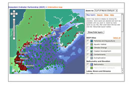 Interactive map showing the locations of monitoring programs for aquatic habitat, climate change, coastal development, contaminants, eutrophication, and fisheries and aquaculture.
|
Habitat Restoration Web Portal
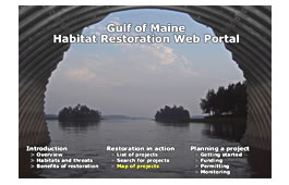 Resources for planning and implementing habitat restoration projects in the Gulf of Maine and its watershed. Mapping tools. Restoration project summaries. Resources for planning and implementing habitat restoration projects in the Gulf of Maine and its watershed. Mapping tools. Restoration project summaries.
Click here for more information.
|
|
Gulfwatch
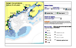 Measuring contaminants in blue mussels to assess the types and concentration of contaminants in coastal waters of the Gulf of Maine. Interactive map. Downloadable data. Measuring contaminants in blue mussels to assess the types and concentration of contaminants in coastal waters of the Gulf of Maine. Interactive map. Downloadable data.
Gulfwatch
|
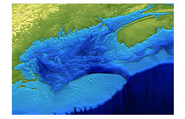
Gulf of Maine Mapping Initiative (GOMMI)
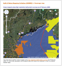 The Gulf of Maine Mapping Initiative (GOMMI) is a U.S.-Canadian partnership of government and nongovernment organizations to conduct comprehensive seafloor imaging, mapping, and biological and geological surveys. The Gulf of Maine Mapping Initiative (GOMMI) is a U.S.-Canadian partnership of government and nongovernment organizations to conduct comprehensive seafloor imaging, mapping, and biological and geological surveys.
|
|
Gulf of Maine KnowledgeBase
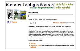 Bibliographic database of scientific papers, technical reports, workshop proceedings, fact sheets, and other information related to ocean and coastal management in the Gulf of Maine and its watershed. Bibliographic database of scientific papers, technical reports, workshop proceedings, fact sheets, and other information related to ocean and coastal management in the Gulf of Maine and its watershed.
|
Regional Habitat Monitoring Data System
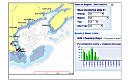 Web-based system that enables sharing, integration, and use of coastal habitat monitoring data. As a proof of concept, the system has been developed initially with data from a limited number of monitoring sites in salt marshes and seagrass beds. Web-based system that enables sharing, integration, and use of coastal habitat monitoring data. As a proof of concept, the system has been developed initially with data from a limited number of monitoring sites in salt marshes and seagrass beds.
|
|
|