|
Shipping lanes shifted to protect whales
[printer friendly page]
 Changing
the location of officially sanctioned shipping lanes into and
out of Boston is not something that can be easily done - the
consequences affect not just American vessels but international
commerce. Shipping lanes are assigned by the International Maritime
Organization (IMO), a part of the United Nations. But a Stellwagen
Bank National Marine Sanctuary-led proposal to move the Boston
lanes, also known as the Traffic Separation Scheme (TSS), to
better protect feeding whales on Stellwagen Bank and in Massachusetts
Bay won overwhelming support at an IMO meeting in late 2006.
A less dangerous course was approved with a July 1, 2007 implementation
date. Changing
the location of officially sanctioned shipping lanes into and
out of Boston is not something that can be easily done - the
consequences affect not just American vessels but international
commerce. Shipping lanes are assigned by the International Maritime
Organization (IMO), a part of the United Nations. But a Stellwagen
Bank National Marine Sanctuary-led proposal to move the Boston
lanes, also known as the Traffic Separation Scheme (TSS), to
better protect feeding whales on Stellwagen Bank and in Massachusetts
Bay won overwhelming support at an IMO meeting in late 2006.
A less dangerous course was approved with a July 1, 2007 implementation
date.
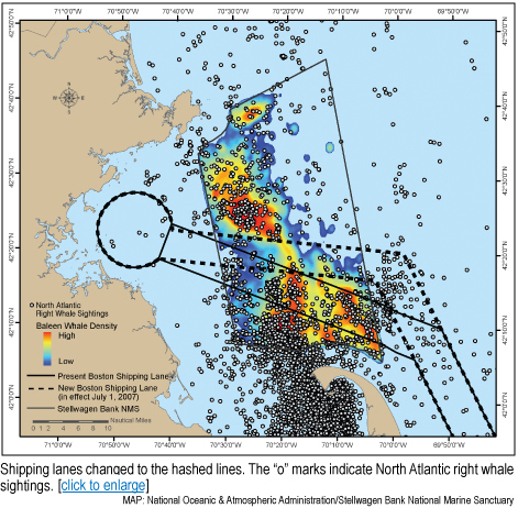
Using a 25-year database of more
than a quarter of a million whale sightings from whale watch
and whale research trips, sanctuary scientists showed that the
heaviest concentrations of whales were located directly in the
shipping lanes. The probability of future sightings in these
areas was substantiated by ecological studies. Most of the whales
target sand lance, a small schooling fish, which prefers the
sandy sediments that predominate in areas with historically high
whale sightings. For endangered North Atlantic right whales,
which feed on small planktonic crustaceans, prevailing currents
push their food into Cape Cod Bay and into the southern portion
of the sanctuary where the lanes were located.
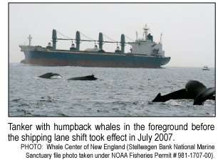
To mitigate the ship strike threat
to great whales, the sanctuary, the National Oceanic & Atmospheric
Administration’s Fisheries Service and the U.S. Coast Guard
proposed that the lanes be narrowed and moved a few miles northward.
Calculations indicated that for most vessels, the change would
only add a few minutes to vessel transit times, but would dramatically
reduce the potential of a ship hitting a whale — 81 percent
for all whales (humpback, fin, minke, northern right) and 58
percent for the critically endangered North Atlantic right whale.
The shipping industry also voiced their support for the northward
shift of the lanes.
This potentially far-reaching
marine mammal conservation effort was made possible by the donation
of whale sightings data from the Provincetown Center for Coastal
Studies, the Whale Center of New England and the North Atlantic
Right Whale Consortium.
A version of this article
appeared in Stellwagen Soundings, Summer 2007. Reprinted with
permission.
|