
Promoting Cooperation to Maintain
and Enhance
Environmental Quality in the Gulf of Maine
Winter 2001
|
|
|
About |
|
Regular columns |
|
Archives |
While coastal southern Maine struggles to control development, Midcoast residents worry as the trend moves north
(related to this article: Countermoves to sprawl and Resources)
By Andi Rierden, Editor
Spread out a maritime chart of the Medomak River as it flows into Maine’s ragged Midcoast, then trace a path along The Narrows between Johnson and Hardy islands and you’ll run your finger into the shoreline of Bremen, Maine. Fiercely grounded in traditions linked to land and sea, this town of 782 residents might be described in a tourist guide as “quintessentially” Maine.
Bremen native Dale Witham has fished, dug for clams and dropped lobster pots along these shores all his life, just as his father and grandfather did before him. Tall, ruddy and intense, he embodies, in large part, the culture and character of this region.
But as commercial and residential development fans out in neighboring towns, transforming the landscape and attracting new faces and lifestyles, Witham often wonders whether he and his community are an endangered lot.
“I’m afraid people like us, people who don’t have a lot of money or education, are going to get pushed out farther inland because we can’t afford to live here,” he says. “It’s happening like the rest of the East Coast. They’re coming in here and building this area up and making it look like the place they left behind. The worst part is, it’s going to be gone before people even realize we lost it.”
Similar anxieties are being voiced throughout Maine’s Midcoast, once
considered by many longtime residents to be immune from the grip of rampant
development and its negative consequences. But as excessive consumption of
Maine’s open space has become all too apparent in the southern part of the
state, coastal towns to the north are also struggling to come up with
land-use
strategies that might prevent the consequences of sprawl from overtaking
their communities.
“People have to understand that we have so much to lose if we don’t try to control growth,” says Amanda Russell, a town planner from Edgecomb. “Otherwise we’re going to end up looking like southern Maine.”
Edgecomb residents recently voted to limit driveways on U.S. Route 1, triple building setbacks to 150 feet, reduce parking and require a 20-foot landscape buffer. The measures are, in part, meant to preserve open space and discourage “impulse shopping” ventures like fast food restaurants from setting up shop, Russell says.
Russell is a founding member of Friends of Midcoast Maine, the first grassroots attempt in the state to take a regional approach to sprawl. The group, composed of land conservation groups, town planners, government and business officials, was launched last year in response to a proposed state road project that called for a bypass around the town of Wiscasset to ease summer traffic congestion. The bypass, Russell says, would have sliced through several towns, disrupting wildlife corridors and wetlands and encouraging more traffic and development. Because of the swell of opposition, the Maine Department of Transportation is now examining alternative routes.
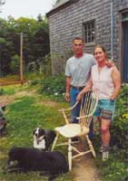 Amanda
Russell and Andy Abello at home in Edgecomb. Photo: Andi Rierden.
Amanda
Russell and Andy Abello at home in Edgecomb. Photo: Andi Rierden.
Raised in a Midcoast fishing village, Russell and her husband, Andy Abello, operate a tree farm and furniture making business in Edgecomb on land he bought in the mid-1970s. Like many lifelong residents and those that settled here during that period, they live a modest lifestyle supported by land-based work. Echoing the sentiments of Dale Witham, Russell says sprawl is slowly but surely eroding the character of her community and other Midcoast towns making it more difficult to earn a living farming, fishing or logging. She points to a former farm down the road from her that is now subdivided into housing lots and fears that more farmers, unable to pay the increasing taxes on their land, will want to retire and sell to developers.
“We want to see legitimate alternatives for large landowners that would give them choices besides turning their land into subdivisions,” she says. “We’re trying to make a blueprint to preserve our natural resources and our rural culture.”
Overall, the alliance is serving as a clearinghouse and policy center to help communities from Bath to Belfast work together to solve transportation, environmental and quality-of-life problems. It’s a radical approach given the state’s tradition of home rule, in which towns and cities enjoy greater autonomy than the county government. But one whose time has come, say Friends’ members.
“We have to learn a new language and a new way of seeing things,” says Amy Haible, Friends’ vice president and Harpswell resident. “If we don’t see ourselves as different parts of a whole we’re not going to make it. Each town is not going to succeed in protecting its own little turf.”
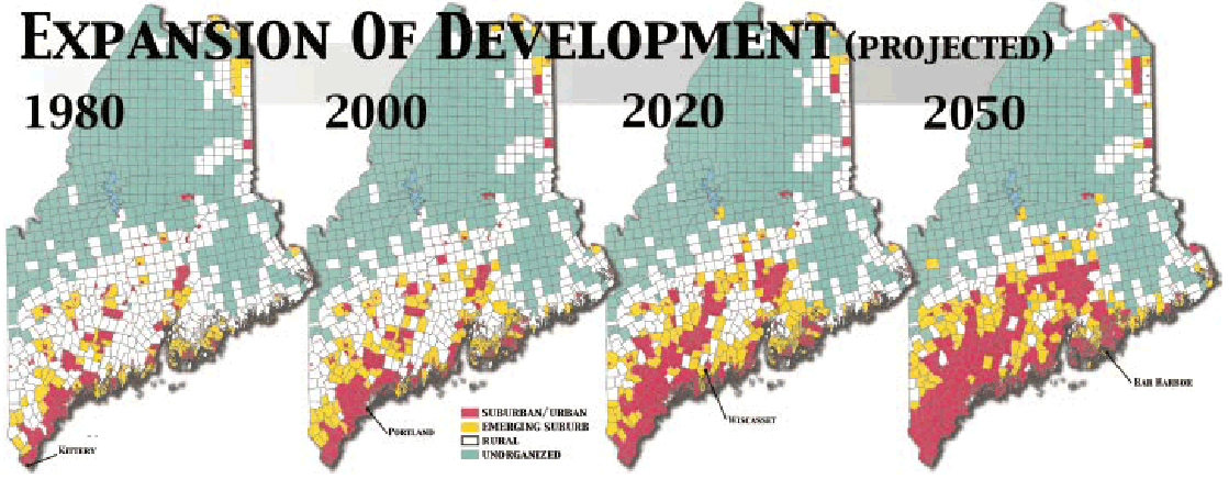
The problem with sprawl
Without question, the public’s increasing desire to live on the coast is driving development up the Gulf of Maine and changing the face of small towns and their surrounding landscapes like never before. And perhaps no other area in the Gulf illustrates this better than in coastal Maine, where over the last couple of decades more land has been developed than in the entire history of the state.
"It's no accident that we Americans,
probably the world's champion
sentimentalizers about nature, are at one
and the same time probably the world's most
voracious and disrespectful destroyers of wild
and rural countryside. Each day,
several thousand more acres of our
countryside are eaten by the bulldozers,
covered by pavement, dotted with
suburbanites who have killed the thing
they thought they came to find."
- Jane Jacobs, architect, circa 1960
Signs of concern are evident in the state legislature, where more than 100 bills now before lawmakers address growth management or sprawl issues, such as property taxes, protection of farmland and subdivision reform.
Blamed for a host of ills from spoiling perfectly beautiful landscapes to forcing up property taxes of longtime residents who are often unable to afford the increase, sprawl has become synonymous with mindless planning. In its path it leaves behind a generic mishmash of subdivisions, access roads, strip malls, off ramps, industrial parks, clogged highways, parking lots and billboards. It is as though, writes James Howard Kunstler, the author of The Geography of Nowhere, “the whole thing had been designed by somediabolical force bent on making human beings miserable.”
Beyond the unsightly clutter, sprawl invokes a deep loss of place and history that cannot be regained. “Sprawl eats up the social capital that holds a community, any community, together,” Evan Richert, director of Maine’s State Planning Office (SPO) has said.
Richert has been sounding the alarm against sprawl for years. In 1997, his office produced the much cited report, The Cost of Sprawl, which details the economic, environmental and social consequences of Maine’s pattern of growth. The report revealed, and the 2000 Census data reinforces those findings, that while Maine’s largest cities are declining in population, some rural communities are experiencing nothing less than a population explosion.
During the 1990s, Maine’s population grew by only 3.8 percent to a total of 1.27 million people, far below the U.S. national average of 13.8 percent. However, most of that growth occurred in coastal towns in Maine’s southern counties. Dayton, for example, grew more than 50 percent, while four other York County towns had growth rates of 30 to 37 percent.
Since the 1970s, the conversion of small towns into bedroom suburbs has expanded the geographic extent of Greater Portland 550 percent, from 96 to 626 square miles. A study by the Brookings Institute released last summer, which calculated the amount of farmland and natural areas lost to development, found that the Portland metropolitan area is consuming more acreage per person than any other city in the Northeast United States at a rate that is among the most wasteful in the nation.
As harmless as one person’s exodus from city to country may seem, when multiplied by the thousands the effect is exponential, says Charles Colgan, an economist at the University of Southern Maine (USM).
“People who are essentially urban dwellers are using up the rural landscape in ways that they think are preserving it for them, but in fact it’s using it up for everybody.”
Colgan and other experts often point to the “unintended consequences” of scattered growth. Despite the decline in population of Maine’s elementary and secondary students, for example, the state funded 124 major school projects; many built to accommodate growth in the new suburbs.
As rural towns balloon, new schools, roads, housing and municipal services are needed to keep up. Gradually, the mounting expenses are absorbed through increased property taxes, a hardship for many rural residents. The taxes of urban residents also rise to support roads and other improvements for commuters and for the needs of an aging and low-income population.
Spreading out means people are becoming even more dependent on automobiles, driving longer distances to work and shop, using more energy and emitting more pollution. Before long, roads have to be upgraded, widened and improved. More parking lots have to be built. And the more we pave paradise, as the song goes, the more nonpoint source pollutants, including oil, grease and toxic chemical runoff from asphalt surfaces; and fertilizers, herbicides and insecticides from agricultural lands and residential lawns, seep into the waterways, degrading wetlands and threatening water quality.
And the costs go way beyond dollars and cents. As farmland and forests transform into subdivisions or malls, the availability of habitat for wildlife declines. Buildings, roads and other manmade barriers can also alter or block essential wildlife corridors, woodlands, streams and lowlands.
“It is no coincidence that almost all of the nonmarine animal species on the Maine Endangered and Threatened List are native to southern and coastal areas of the state, those that are now under the most development pressure,” states a 1996 report by the Maine Environmental Priorities Project.
Turning fears into action
Such dire implications of sprawl bring us back to why Maine’s Midcoast residents, both old and new, are nervous. Norma Dreyfus and her husband moved to Westport Island,year-round population of around 400,from Westchester County, New York, a suburban enclave north of New York City, two and a half years ago. Two months after they bought their house they heard about the Wiscasset corridor road construction project.
“We had come to Maine for the natural beauty, the lack of urban living, the quiet and the people,” says Dreyfus, a pediatrician. “Then we read about a possible widening of U.S. 1 and the potential for a four lane highway. We were shocked, because that’s what we left behind.”
Soon after, Dreyfus alerted Westport residents to the news at a local meeting. From there, they formed the Friends of Coastal Preservation to monitor road projects as part of a larger Midcoast scheme to manage growth. FCP along with the Conservation Law Foundation and the Sheepscot River Association are part of the Friends of Coastal Maine partnership.

The draw of Maine's rugged coastal beauty: Seapoint Beach near Kittery. Photo: Daryl-Ann Hurst.
Maine first addressed sprawl in 1988, with the adoption of the Comprehensive Planning and Land Use Act, mandating that all communities devise long-range growth plans and land use ordinances. For its part, the SPO has been holding workshops and consulting with towns to help them integrate measures to efficiently manage growth. Based on the so-called “smart growth” concept, they include compacting areas for commercial and residential development and allowing for more open space, much like a traditional village. Studies in Maine have shown that most homebuyers desire to live in “walkable” neighborhoods with interconnected streets and a civic core as opposed to suburbs. “We have been undermining traditional neighborhoods for years,” says Beth Della Valle, a state planner. “We build on all the vacant spaces rather than recognizing they are necessary for breathing room.”
To relieve development pressure in rural areas, SPO is providing low-interest loans to towns and cities to help upgrade their infrastructures and plan more compact neighborhoods.
Last year, state legislators also adopted an act aimed to curb sprawl by providing $1.7 million to communities to assist with growth management.
Westport and dozens of other towns are revising their comprehensive plans to conform to the state’s growth management goals. Stanley Lane, a town selectman, calls the process a balancing act. “We’re putting in areas for commercial growth and land for affordable income housing and trying to come to grips with what to do with subdivisions,” he says. “Basically, we’re trying to make order out of potential chaos.”
Several coastal communities have limited the number of building permits issued annually, ostensibly to control subdivision development and protect open spaces. The use of so-called growth caps has stirred mixed criticism from planning officials and others who say they merely push development elsewhere, instead of channeling it to places that can best absorb it.
“Growth is going to continue to happen regardless,” says Colgan of USM. “It’s a delusion for people to think these caps are going solve the problem. It’s like putting your finger in the dike. When the dike gives way you are going to be in for a long swim.”
But proponents say that with increasing development, imposing limits on building helps small towns grow at a rate that everyone can adjust to. Last spring, Bremen voters limited the number of building permits to eight each year. For many residents, the move represented a show of community self-determination and preservation.
Though Bremen’s taxes are slowly increasing, says Steve Barnes, “all around us where we see sprawl the taxes are spiking.” Barnes and Dale Witham were among a group of fishermen to support the housing cap.
Educated as a naval architect and marine engineer at the Massachusetts Institute of Technology, Barnes “dropped out of Boston’s fast lane” 24 years ago and moved to Bremen to live a traditional Maine lifestyle as a farmer and fishermen. He and his wife bought 40 acres of land (16 hectares) with a quarter mile of saltwater frontage for $20,000 (CDN$32,000) and lived without electricity for seven years. It took a year before local people would speak to him, he says. Today he serves as Bremen’s shellfish warden and on the clam conservation committee and helped write the town’s harbor ordinance that gives fishermen priority to moorings.
The latest wave of newcomers, he says, include people who genuinely want the region to retain its character, and those who “have made huge amounts of money and can afford to buy shore lands at terribly inflated prices than what many longtime residents are used to. They don’t see the land and sea in a dynamic relationship. For them it’s just something to look at, something to show their friends, a trophy view.”
Responding to the state’s predictions of continuing growth in coastal towns for decades to come, Barnes wonders why this “huge migratory movement” has to concentrate predominantly on the coast when there are million of acres inland. When all is said and done, he says, “If we don’t take care of these towns we’re all going to get driven out of here because we’re sitting on properties too good for poor people to have.”
Countermoves to sprawl: Maine's way of preserving lands
(related articles: The dreaded spread of sprawl and Resources)
Maine's approach to land preservation involves a partnership philosophy whereby government agencies, nonprofit organizations and landowners work in tandem to acquire significant lands. This alliance has been largely responsible for protecting more than 170,000 acres in the state’s coastal zone, about 9.8 percent of the total area.
On the government side, for example, the U.S. Fish and Wildlife Service has helped add acreage to the federal national wildlife refuge system, the state's wildlife management areas and private land trust holdings. Maine Department of Inland Fisheries and Wildlife and Maine Department of Conservation have also acquired lands and added them to state wildlife management areas and state parks. Two statewide nonprofit conservation organizations, The Nature Conservancy (Maine Chapter) and Maine Coast Heritage Trust, work with government agencies and local land trusts to acquire properties on the mainland and on islands. In the past decade, more land trusts have been established in coastal communities, so that today there are over 50 protecting land at the local level.
One of the most significant developments in coastal land acquisition occurred in 1987, when Maine voters approved a $35 million (CND$55.7 million) bond to acquire lands of statewide significance. Since it was founded, the Land for Maine's Future Program has acquired 65,000 acres, 16,046 (6,500 hectares) of which are in the coastal zone. An additional $50 million bond was approved in 1999, and more large acquisitions are anticipated over the next five years. The federal government has also provided millions of dollars for land acquisition in Maine through its Coastal Wetland Grants, North American Wetlands Conservation, National Fish and Wildlife Foundation, Forest Legacy and Land and Water Conservation Fund grants. For more information and links to land preservation activities in Maine, visit the Maine Land Trust Network page at www.mltn.org.
(related articles: The dreaded spread of sprawl and Countermoves to sprawl)
Find out more about Maine’s initiatives to manage growth along the coast by visiting the State Planning Office’s Web site at www.state.me.us/spo.
The U.S. Environmental Protection Agency’s page, “Smart Growth Strategies for New England” provides excellent links on livable communities and other land use issues. Go to: www.epa.gov/region01/ra/sprawl/links.html.
For background and facts about sprawl in the United States visit the Natural Resources Defense Council page at www.nrdc.org/cities/SmartGrowth/default.asp.
“Habitat-based Approach to Open Space Planning” describes a collaboration between federal and state agencies in Maine to map key habitat to encourage protection of priority areas. The maps are used as tools to help local planners. For more details visit www.state.me.us/newsletter/Aug2001/habitat.htm.