*Web only content*
Sensors, radar to give more details on hurricanes
Related stories:
Hurricanes: preparing for the next big one
Core samples:
Examining history to predict the future
Researchers at the Massachusetts Institute of Technology (MIT) are using acoustic sensors to measure how powerful a hurricane is before it hits land, potentially helping save lives or avoiding the high cost of unnecessary evacuations. In a separate development, the U.S. National Hurricane Center (NHC) this summer will implement a technique developed at the National Center for Atmospheric Research (NCAR) in Colorado and the Naval Research Laboratory (NRL) in Washington, DC, that helps forecasters continuously monitor landfalling hurricanes, giving them frequent and detailed images of a storm’s location.
 To date, the only sure way to measure the strength of a hurricane has been sending airplanes fitted with wind-speed instruments to fly through intense winds into the eye of the storm. That is an expensive approach, according to MIT, with the specialized planes costing about $100 million each, and a single flight costing around $50,000. To monitor only one approaching hurricane could require a dozen such flights. To date, the only sure way to measure the strength of a hurricane has been sending airplanes fitted with wind-speed instruments to fly through intense winds into the eye of the storm. That is an expensive approach, according to MIT, with the specialized planes costing about $100 million each, and a single flight costing around $50,000. To monitor only one approaching hurricane could require a dozen such flights.
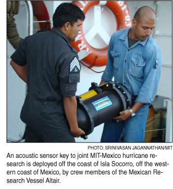
Nicholas Makris, director of MIT’s Laboratory for Undersea Remote Sensing, thinks a better way would be to place underwater microphones, or hydrophones, deep beneath the surface in the path of an oncoming hurricane. It’s then possible to measure wind power as a function of the intensity of the sound of churning waves and bubble-filled froth.
Makris has been conducting theoretical work to analyze this potential measurement method for years, and recently compiled the first piece of direct data confirming his calculations. Makris and his former graduate student Joshua Wilson, in a paper accepted for publication in Geophysical Research Letters, showed that Hurricane Gert in 1999 passed nearly over a hydrophone anchored 800 meters (875 yards) deep above the mid-Atlantic Ridge at about the latitude of Puerto Rico, and the same storm was monitored by airplanes within the next 24 hours. The results were exactly what Makris had predicted, and provided the first experimental validation of the method. Makris said there was less than a 5 percent error, or about the same as that from aircraft measurements.
In collaboration with the Mexican Navy’s Directorate of Oceanography, Hydrography and Meteorology, the team installed a hydrophone in waters close to the island of Socorro, off Mexico’s west coast and one of the world’s most hurricane-prone areas, and they are waiting for a storm to come by and further validate the technique.
The hydrophones also could monitor the amount of sea salt entering the atmosphere as a result of the churning ocean waves. The sea salt has a major impact on global climate because it scatters solar radiation that regulates the formation of clouds.
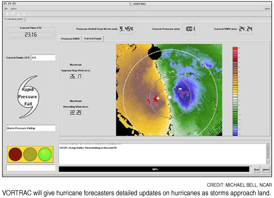
A different technique to be used by the National Hurricane Center, called VORTRAC or Vortex Objective Radar Tracking and Circulation, was successfully tested by the hurricane center last year.
The system relies on existing Doppler radars along the U.S. coast. The system provides details on hurricane winds and central pressure every six minutes, indicating whether the storm is gathering strength in the final hours before reaching shore.
NCAR scientist Wen-Chau Lee explained in a statement: "VORTRAC will enable hurricane specialists, for the first time, to continuously monitor the trend in central pressure as a dangerous storm nears land. With the help of VORTRAC, vulnerable communities can be better informed of sudden changes in hurricane intensity."
One of VORTRAC's strengths is that it can use radar data to calculate the barometric pressure at the center of a hurricane, a key measure of its intensity.
"VORTRAC allows us to take the wind measurements from the radar, turn the crank, and have a central pressure drop out of a calculation," Colin McAdie, a meteorologist at the National Hurricane Center, said in a statement. "This will be a valuable addition to the tools available to the forecaster."
Rapidly intensifying storms can catch vulnerable coastal areas by surprise. Last year, Hurricane Humberto struck near Port Arthur, Texas, after unexpectedly strengthening from a tropical depression to a hurricane in less than 19 hours. In 2004, parts of Florida's southwest coast were caught unprepared when Hurricane Charley's top winds increased from 110 to 145 miles per hour (177 to 233 kilometers per hour) in just six hours as the storm neared land.
Lee and his collaborators applied VORTRAC retroactively to the two hurricanes and found that the technique would have accurately tracked their quick bursts in intensity. The VORTRAC team developed a series of mathematical formulas that combine data from a single radar near the center of a landfalling storm with general knowledge of Atlantic hurricane structure in order to map the approaching system's rotational winds. VORTRAC also infers the barometric pressure in the eye of the hurricane, a very reliable index of its strength.
Forecasters using VORTRAC can update information about a hurricane each time a Doppler radar scans the storm. Without such a technique, forecasters would need at least two coastal radars in close proximity to each other in order to obtain the same information. But most of the network's radars are too far apart to qualify.
Each radar can sample conditions out to about 120 miles (193 kilometers). This means VORTRAC can track an incoming hurricane for at least several hours, and possibly even as long as a day or more, depending on the storm's speed, trajectory and size.
|