|
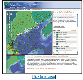 New version of ESIP monitoring map available New version of ESIP monitoring map available
[printer friendly page]
The Ecosystem Indicator Partnership
(ESIP) of the Gulf of Maine Council has unveiled a new version
of the ESIP Monitoring Map. The Monitoring Map is an interactive
tool to consolidate information on monitoring in the Gulf of
Maine. With as many as 300 programs now in place in the Western
Atlantic and the Gulf of Maine, ESIP is working toward the coordination
and harmonization of monitoring programs in the Gulf of Maine.
The majority of the programs are marine and coastal, though some
are terrestrial ones.
The ESIP long-term focus is on
data synthesis and reporting focused on six areas: aquatic habitat,
climate change, coastal development, contaminants, eutrophication
and fisheries/aquaculture. But the initial steps in the interest
of cross-program coordination have led to the development of
an integrated system for identifying monitoring locations.
ESIP’s new version of the
monitoring map allows users to zoom to specific locations or
filter monitoring programs by indicator or organization. Site
information includes specific location and maps, along with information
on neighboring sites.
If further detail is needed,
users can follow a Web link to the parent organization. Users
can also opt to download data or make PDFs of their specific
searches. The new monitoring map and revised user guide can be
accessed on the ESIP
Web page.
For more information on ESIP’s
activities or to add programs to the interactive map, please
contact Christine Tilburg at ctilburg@securespeed.us.
|