|
Science Insights
A standard approach to monitoring dam removal
By Peter H. Taylor
[printer friendly page]
 Almost
every day, when I am driving around the Maine town where I live,
I cross a bridge over the Royal River. It is a scenic river about
150 feet (46 meters) wide that drains an area of 365 square kilometers
(141 square miles) into Casco Bay. For more than a century, the
river was the town’s lifeblood. Dams powered mills that
provided jobs for hundreds of people. Almost
every day, when I am driving around the Maine town where I live,
I cross a bridge over the Royal River. It is a scenic river about
150 feet (46 meters) wide that drains an area of 365 square kilometers
(141 square miles) into Casco Bay. For more than a century, the
river was the town’s lifeblood. Dams powered mills that
provided jobs for hundreds of people.
Today, the Royal River has lost
its prominence in the local economy. The mills are mostly gone,
and the town has become a quiet, residential suburb. Now people
mainly value the river as a scenic feature and a place for recreation.
It no longer provides many jobs. But the dams are still here,
impeding the flow of water from uplands to the sea.
When I am driving across the
river, I usually glance downstream at one of the dams. I muse
about the fish that cannot migrate because of it and the other
lost connections between land and sea. These dams are such longstanding
elements of the local scene, and seem so integral to the place,
that it is easy to forget they were not always here. Except for
the last few hundred years — a blip in geological time —
the Royal River flowed free. How would the ecosystem respond
if its dams were removed?
Covering 179,000 square kilometers
(69,000 square miles), the Gulf of Maine’s watershed encompasses
the entire state of Maine and parts of New Hampshire, Massachusetts,
Nova Scotia, New Brunswick and Quebec. The Royal River is one
of many rivers that drain water from this land area into the
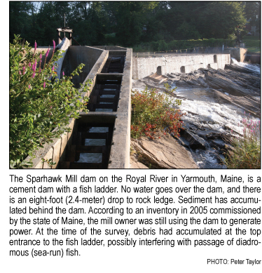
Gulf. It has two dams, according to the Inventory of Potential Habitat Restoration Sites.
The number of dams on these rivers
is astounding. Rivers in the U.S. portion alone of the Gulf of
Maine’s watershed have more than 4,800 dams. State inventories
found 2,506 dams in New Hampshire, 782 in Maine and 1,579 in
Massachusetts. (Inventories varied in comprehensiveness, and
Maine undoubtedly has many more than 782 dams.) Many of these
dams are aging and are no longer needed, but they continue standing
as relics.
While the Royal River is no longer
the economic lifeblood of my town, it continues to be —
just as it always has been — a critical part of the ecosystem.
The freshwater ecosystem of the river itself connects intimately
in innumerable ways with the surrounding terrestrial ecosystem
and the marine ecosystem into which it flows. Like plaques clogging
an artery, the dams on the Royal River impair the health of the
river and, in turn, the larger ecosystem.
Recognizing that removing dams
can benefit the ecosystem, the economy and public safety, government
agencies, non-government organizations and private parties have
demolished some 600 dams throughout the United States in recent
decades. Some 20 dams have been taken down in the U.S. portion
of the Gulf of Maine’s watershed since 1995, and 20 more
are being considered for removal.
These projects require tremendous
investments in time and money, and sometimes they are contentious
because of the socioeconomic significance of dam removal. It
makes sense that ecological changes should be monitored afterwards
to determine if the goals were accomplished and to learn the
best ways to conduct dam removals. For most dam removals, however,
little information is collected about the riverbed, wildlife
and habitats. When monitoring does occur, the methods vary tremendously,
making it difficult to compare outcomes of different dam removals.
We know far less than we should about how the ecosystem responds
after a dam is removed.
An initiative led by the River
Restoration Monitoring Steering Committee of the Gulf of Maine
Council on the Marine Environment is addressing this knowledge
gap. Working with more than 70 scientists, resource managers
and watershed restoration practitioners from around the Gulf
of Maine, the Steering Committee has developed a standardized
approach to environmental monitoring of dam removal sites. According
to a document produced by the Steering Committee with assistance
from the New Hampshire Coastal Program, if this approach is adopted
scientists should be able to:
- evaluate the performance of
individual habitat restoration projects;
- assess the long-term ecological
response of regional restoration efforts;
- advance our understanding of
restoration ecology and improve restoration techniques;
- better anticipate the effects
of future stream barrier removal projects; and
- communicate monitoring results
to stakeholders and the public.
In this standardized approach,
the Steering Committee has identified eight critical monitoring
parameters for every dam removal site: monumented cross sections,
longitudinal stream profiles, stream bed sediment grain size
distribution, photo stations, water quality, riparian plant community
structure, macroinvertebrates and fish passage assessment. A
forthcoming guide produced by the Steering Committee in collaboration
with the Gulf of Maine Science Translation Project and the New
Hampshire Coastal Program will present the rationale and methods
for using these parameters. Release of the monitoring guide will
be announced on the Gulf
of Maine Council’s Web site.
Perhaps one day, as I drive across
the Royal River, I will glance downstream at where a dam used
to be and see a group of scientists wading in the water, using
these standardized monitoring methods. Then I can find out how
the ecosystem responds to the river flowing free again.
Peter H. Taylor is a consultant for the Gulf of Maine
Science Translation Project.
The online Inventory of Potential Habitat Restoration Sites
provides information, photos and maps of dams and other human
impacts on the Royal River and three other rivers that flow into
the Gulf of Maine. Or, explore the sites on an interactive map.

|