
![]()
Volume 5, No. 3
Promoting Cooperation to Maintain and Enhance
Environmental Quality in the Gulf of Maine
|
||||||||||
|
Regular columns |
|
Current stories |
|
Archives |
|
About |
The Ipswich River and the price of urban sprawl
By Maureen Kelly
On the North Shore of Massachusetts, where the Ipswich River's quiet waters zigzag through Massachusetts Audubon's 2,800 acre wildlife sanctuary, the river appears untouched by the sprawling development that spreads from the Greater Boston area. Deer come to the riverbank to drink, turtles bask on logs, muskrats scurry at river's edge, and birds - from egrets to red-winged blackbirds - fly over the wetlands. From there, the river flows east to Ipswich and empties into Plum Island Sound. The estuary is part of the Great Marsh on the Atlantic flyway.
The Audubon Society, two state parks and the Essex County Greenbelt
Association, a local land trust, protect tracts of land surrounding the
river in Essex County. Yet before it reaches this point, the 35-mile river
meanders through Middlesex County past streams of traffic, industrial parks
and suburban housing developments. Here, fewer measures have been taken to
buffer the river from encroaching development.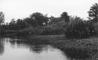
The quiet waters of the Ipswich flow through the MA Audubon Society�s wildlife sanctuary on the North Shore. Photo: Maureen Kelly
The headwaters form in the marshlands of the towns of Burlington and Wilmington, just west of Interstate 93. While the land surrounding the headwaters bears little resemblance to that near the mouth, the whole length of the river suffers from over-development and withdrawals of water by municipalities. Fourteen towns draw all or some of their water from the river to supply approximately 350,000 people with drinking water.
As towns on the North Shore grow, development threatens to impair the river's water quality while demand for water increases. Already, so much water is being taken from the river that withdrawals are altering the hydrology of the river.
Water consumption plus pollution
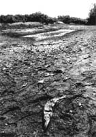
In recent years, low stream flows have been recorded regularly in the Ipswich River, particularly in the summer when suburbanites use more water to water lawns and fill swimming pools. On the upper sections of the river - most notably around North Reading - the waters cease to flow downstream during extreme dry years.
 "During
the summer the river literally runs backwards in areas," says Peg Lawrence,
director of development for the Ipswich River Watershed Association (IRWA),
a nonprofit organization working to restore the health of the river.
"During
the summer the river literally runs backwards in areas," says Peg Lawrence,
director of development for the Ipswich River Watershed Association (IRWA),
a nonprofit organization working to restore the health of the river.
The Ipswich River near North Reading , MA, during a summer drought in 1995. Photo: Kerry Macklin
In the North Reading area, the river can turn into a series of ponds, she says. Riffles, the shallow areas where water tumbles over rocks, are the first places to dry out. River fish depend on riffles to oxygenate the water. When riffles dry out, the remaining stagnant waters warm, hold less oxygen and become uninhabitable for river fish.
Such drought conditions existed in 1995, 1997 and 1999. The lowest stream flows on record - based on sixty years of observation - occurred in the spring and summer of 1999, according to the Ipswich River Basin Conservation Report Card, an annual IRWA publication.
The report card states that in 2000, the U.S. Geological Survey created a computer-based hydrology model of the river and determined that water withdrawals were reducing summer flows "by as much as 90 percent." The USGS found that some 20 to 25 million gallons of water are displaced from the watershed each day. Most of that water enters wastewater treatment plants outside the watershed and is expelled into the ocean rather than returned to the Ipswich's basin. Groundwater also drains out of the aquifer as it leaks into cracked or corroded sewer pipes.
Furthermore, towns that pump groundwater are contributing to the alteration of the river's hydrology by lowering the water table. While unimpeded groundwater naturally flows toward the river, wells intercept the water as it takes its natural course and can change the flow of groundwater away from the streambed.
 Even
periods of heavy precipitation are not enough to recharge the river's
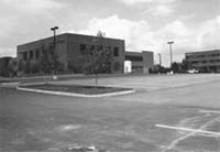
aquifer. The paved surfaces of roads and parking lots prevent rainwater and
snowmelt from seeping into the ground. Instead, the water runs off into the
river and can cause flooding, as occurred during heavy rains last March.
Even
periods of heavy precipitation are not enough to recharge the river's
aquifer. The paved surfaces of roads and parking lots prevent rainwater and
snowmelt from seeping into the ground. Instead, the water runs off into the
river and can cause flooding, as occurred during heavy rains last March.
Roads and other impervious surfaces like this parking lot abutting the headwaters of the Ipswich in Wilmington, MA, can cause flooding and carry oil and other pollutants into the watershed. Photo: Maureen Kelly
The same impervious surfaces that cause flooding are the primary avenues for pollution entering the river. Except for a few small dischargers in the upper basin, there are few point source polluters along the river today, Kerry Mackin, executive director of IRWA, says. She adds that the most significant source of pollution comes from storm water run-off.
Roads and expansive parking lots provide acres of hardtop for rainwater
to flow over, picking up and carrying oil and other toxins into the
wetlands. Landscaping of private homes adds pesticides and fertilizers to
the mix of pollutants entering the river.
A new era for the river?
While sprawl is exacerbating the low flow and water quality problems on the
Ipswich River, efforts are underway to mitigate the impacts of future
population growth and development.
"The good news is that because of the explosive growth rate in this area, towns are very open to innovative ways of protecting their environment and their community character," says Andrea Cooper, the North Shore regional coordinator for the Massachusetts Office of Coast Zone Management.
CZM, working in conjunction with the Massachusetts Audubon Society, is combating sprawl by working with communities to inform them of alternative development models like Open Space Residential Design. The model gives incentives to developers and landscape architects to create subdivisions that are eco-friendly. Municipal bylaws that allow homes to be clustered, for example, could preserve areas of "conservation value" and reduce the space needed for roads. CZM also hopes to convince landscape architects to use plants that are drought resistant and that require less pesticide and fertilizer.
Under the aegis of the Massachusetts Executive Office of Environmental Affairs, towns in the upper watershed are partnering to create a master plan that will address the impacts of growth, find ways to conserve water and improve water quality.
At the other end of the river, in Ipswich, the Massachusetts Division of Marine Fisheries and IRWA are working to restock the river with blueback herring, once bountiful in the river. IRWA members spent over 400 hours during a three-week period this spring counting herring as they swam upriver. They counted 370 fish, up from about 40 last year, Lawrence says. Nevertheless, these fish have little hope of surviving if low flows strand them. Their survival hinges on how 14 towns manage their water supply.