
![]()
Volume 5, No. 3
Promoting Cooperation to Maintain and Enhance
Environmental Quality in the Gulf of Maine
|
||||||||||
|
Regular columns |
|
Current stories |
|
Archives |
|
About |
Preserving the Lamprey before it's too late
By Andi Rierden, editor
The Great Bay in New Hampshire is one of the most ecologically sensitive nearshore environments in the Gulf of Maine. Encompassing a 200 square-mile area, the estuary is formed by the confluence of five rivers. The largest river, the Lamprey, is among the area's more pristine waterways, and plays a significant role in the bay's health.
Draining a 212 square-mile watershed, the river begins in the Saddleback Mountains in Northwood, New Hampshire, and wends 47 miles through corridors of forests, wetlands and agricultural lands before it turns tidal in Newmarket and empties into the bay. Relatively untouched by development, it remains a thoroughfare for wildlife.
All six species of turtles native to the state are found along the Lamprey, including the rare spotted, wood and Blanding's turtles. Researchers have documented 172 wetland and aquatic plant species along the river and 159 species of birds.
Of the handful of rivers in the Gulf of Maine region designated as Wild and Scenic by the federal National Park Service, the Lamprey is the only coastal river (the designated area embodies 24 miles from Newmarket to West Epping).
Driving along its shorelands past lush meadows, forest glens and long, cool canopies of hardwoods is like entering an earlier era. Thick walls of vegetation buffer the banks of the river along with remnants of stone walls from 19th and 20th century grist mills. Great blue herons and black ducks forage through the slow-flowing waters.
Yet in a state described as the fastest growing in New England, where much of the growth is concentrated in the coastal arena, those who know the river well fear the Lamprey may be at the end of its halcyon days.
 Judith
Spang came to live along the Lamprey in Durham more than two decades ago.
She has worked ever since to preserve its natural character. Born and raised
along the shoreline of Rhode Island, Spang grew up surrounded by farmlands
and miles of open space. But as time moved on, the land she knew as a child
transformed into great blocks of subdivisions. "It got to the point that
I'll go back for visits and not even recognize the fields and woods where I
used to play," she says. "It broke my heart and changed my life."
Judith
Spang came to live along the Lamprey in Durham more than two decades ago.
She has worked ever since to preserve its natural character. Born and raised
along the shoreline of Rhode Island, Spang grew up surrounded by farmlands
and miles of open space. But as time moved on, the land she knew as a child
transformed into great blocks of subdivisions. "It got to the point that
I'll go back for visits and not even recognize the fields and woods where I
used to play," she says. "It broke my heart and changed my life."
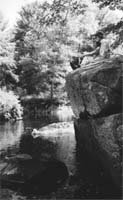
Judith Spang (left) and Margaret Watkins overlooking the section of the Lamprey River designated as Wild and Scenic. Photo: Andi Rierden.
Spang is serving her second term as a state representative from Durham and also heads the Lamprey River Advisory Committee (LRAC), the group responsible for reviewing all projects with potential impact on the river.
As a member of the Durham Conservation Commission, Spang helped craft an ordinance for the Town of Durham, requiring homeowners to retain a vegetative buffer of 150' along shorelands. Doing so helps filter pollution from leachate and runoff, stabilizes banks and provides habitat for wildlife. The ordinance has helped the Lamprey keep its ecological integrity in tact. Her work with the Lamprey River Watershed Association was also instrumental in obtaining special protection status for portions of the Lamprey at both the state and federal level (LRAC was formed as a result).
Signs of strain
On a walk along the river's edge, Spang says the surrounding region is slowly but surely changing. On the horizon in Lamprey's watershed are proposals for an 18 hole golf course and a "big box" shopping development.
"As a planner I get concerned that once these commercial hubs begin to develop everything else will begin to grow," Spang says. "As the population increases, eventually there is going to be a lack of space for people and as that begins to unfold, a lot of these regulations meant to protect our natural spaces are going to be under incredible pressure."
The Lamprey is already showing signs of strain. Beth Malcolm heads the New Hampshire Department of Environmental Service's (DES) Volunteer River Assessment Program, which has monitored the Lamprey for three years. Although it will take several years to get a quantifiable picture of the river's overall water quality, Malcolm says, increased growth is already beginning to stress the waterway. "The Lamprey is fairly clean," she says. "But it is being challenged more than our northern rivers by development."
A major challenge is the amount of water drained from the river by several operations, including a lumber company, the Town of Durham and the University of New Hampshire (UNH), which is projecting a significant rise in enrollment. According to DES records from 1995 to 1999, withdrawals averaged 5.7 million gallons per day on a 13 mile stretch from Newmarket to Epping. A long range management plan to address water taken from the state's rivers by restricting consumption in times of drought or low water conditions is in the final stages of revision before it goes to the legislature. The plan calls for a study of 13 designated rivers, including the Lamprey, to determine the flow levels needed to safeguard their ecological and recreational resources.
Wayne Ives, a hydrologist with DES's Watershed Management Bureau, who is helping to develop the plan, says the rules are needed to maintain normal variations in the river system. "Most of the species in the rivers have evolved because they've been able to survive and establish their habitats despite variations like droughts and high flows that occur naturally," Ives says. "The flow rules would prevent excessive withdraws and excessive variability caused by our actions that make it impossible for the normal species that live in these rivers to survive."
Businesses have criticized the plan saying it would be too expensive to create ponds, dig wells and build storage tanks to save water for times when the state cuts their supply. Recent revisions in the plan call for negotiations among all water users on the water withdraw rules.
Ives adds that DES is also planning an education component to urge all residents to conserve water. "People might think New Hampshire has plenty of water, but from what we've seen in Connecticut and Massachusetts that's not really the case," he says. "We need to take steps before we get into situations like the Quinnipiac or the Ipswich rivers [see article opposite page]. We need to start managing this before we get into crisis mode."
The LRAC has negotiated with the Town of Durham and UNH, which have agreed to reduce intake from the river when levels drop. Even so, Spang says, there are no state restrictions on how much a user can withdraw. She adds that during the summer the decline in the river's water level is visually noticeable. On behalf of LRAC, Spang has testified at public hearings, urging the state to go forward with the management plan.
Margaret Watkins, a natural resources planner for the National Park Service, which funds the LRAC and monitors activities on the Wild and Scenic portion of the Lamprey, agrees that a plan to control water withdrawals is essential, but open to contention. "It's a very science based formula," Watkins says, referring to the proposed flow rules. "Then there's the whole negotiating part which is always going to be political. The system is good but it will depend upon the operations of the users."
Land conservation is key
Along with supporting water conservation measures, the LRAC encourages landowners to place a portion or all of their property into conservation easements or to sell or donate it to conservation organizations. Watkins worked closely with Fran and Paul Verrette, who have lived along the Lamprey for 33 years. Two years ago they placed 100 acres of their property under a conservation easement, which is held by the Town of Lee. "We knew we had to do something, and we didn't want the land developed," Fran Verrette says. She explains that the easement is a binding agreement stating that their land cannot be developed, "for perpetuity." The property includes a forest, wetlands and one half mile of riverfront and is used by college students and school children for research purposes.
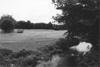 Land
conservation easements such as the above parcel near Lee, NH, is a key
component of a plan to safeguard the Lamprey from encroaching development.
Photo: Andi Rierden.
Land
conservation easements such as the above parcel near Lee, NH, is a key
component of a plan to safeguard the Lamprey from encroaching development.
Photo: Andi Rierden.
Earlier this year, a 211-acre tract with more than three miles of river frontage that was slated to become an 18 hole golf course, was acquired by the Nature Conservancy with funds from the National Oceanic and Atmospheric Administration. Another 120 acres covering one and a half miles of riverfront in Epping was purchased by the Society for the Protection of New Hampshire Forests with financial assistance from LRAC and other donors.
The LRAC and the Town of Lee are in negotiation with a local farmer to place an easement on 140 acres of land along the Lamprey. Given the tenuous future of the region in terms of development, Watkins says, "I'm convinced that the only way we're going to save land along the river is through land conservation."